
Station XL S143 - Big Creek Scout
Network: XL97 - Deep Probe (Archean-Proterozoic)
Nearby stations (2 deg radius)
| Station | Name | (Lat, Lon) | Start / End | Elevation |
| S143 | Big Creek Scout | (38.69, -108.73) | 1997-05-09 / 1997-12-31 | 2700 m |
| Crust2 Type: | Q3,orogen/43km no ice, Appalachians, 3 km seds. |
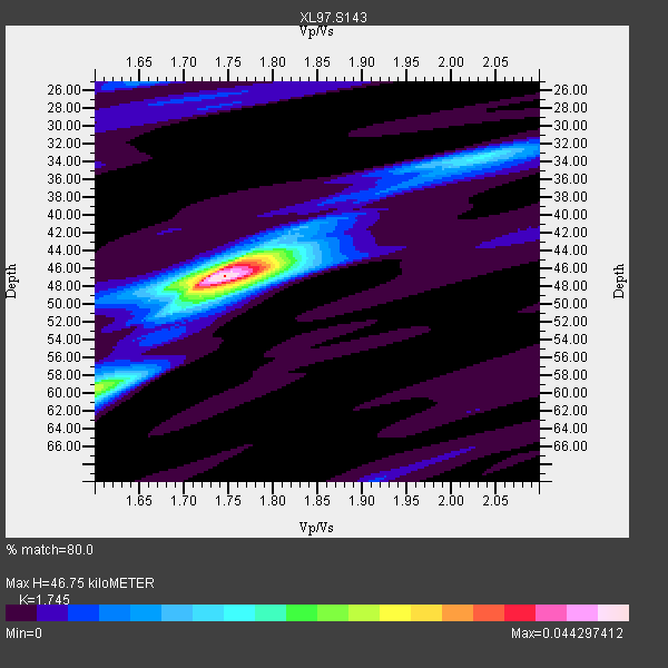
| Thickness Estimate: | 47 km |
| Thickness StdDev: | 1.3 km |
| Vp/Vs Estimate: | 1.75 |
| Vp/Vs StdDev: | 0.02 |
| Vs Estimate: | 3.605 km/s |
| Poisson's Ratio: | 0.26 |
| Peak Value: | 0.04 |
| Assumed Vp: | 6.291 km/s |
| Ps Weight: | 0.33333334 |
| PpPs Weight: | 0.33333334 |
| PsPs Weight: | 0.33333328 |
| Residual Complexity: | 0.479 |
| Nearby stations H: | +- |
| (2.0 deg) Vp/Vs: | +- |
5 with match > 90% ( 22.727272 %) and 10 with match > 80% ( 45.454544 %) out of 22.
Download stack as xyz text file.
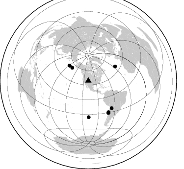
Azimuth Distribution of Events:
Prior Results for this Station
| Study | Thickness | Vp/Vs | Vp | Vs | Poissons Ratio | Extra |
| EARS | 47 km | 1.75 | 6.291 km/s | 3.605 km/s | 0.26 | |
| Crust2.0 | 43 km | 1.76 | 6.291 km/s | 3.577 km/s | 0.26 | Q3,orogen/43km no ice, Appalachians, 3 km seds. |
| Global Maxima | 47 km | 1.75 | 6.291 km/s | 3.605 km/s | 0.26 | amp=0.044297412 |
| Local Maxima 1 | 59 km | 1.60 | 6.291 km/s | 3.932 km/s | 0.18 | amp=0.024286183 |
| Local Maxima 2 | 45 km | 1.76 | 6.291 km/s | 3.579 km/s | 0.26 | amp=0.020793699 |
| Local Maxima 3 | 33 km | 2.04 | 6.291 km/s | 3.091 km/s | 0.34 | amp=0.012821874 |
| Local Maxima 4 | 48 km | 1.75 | 6.291 km/s | 3.584 km/s | 0.26 | amp=0.011567357 |
| Predicted Arrivals for vertical incidence (zero ray parameter) | |
| Ps | 5.54 SECOND |
| PpPs | 20.40 SECOND |
| PsPs/PpSs | 25.94 SECOND |
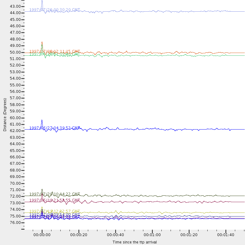
Events Processed for this Station
Download zip of receiver functions as SAC
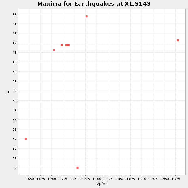
Plot maxima for each earthquake.
Events Used in the Stack
(10 events)| Radial Match | Distance | Baz | FERegion | Time | Lat/Lon | Depth | Magnitude |
| 96.233505 | 49.6 deg | 309.051 deg | Andreanof Islands, Aleutian Is. | 1997/06/17 21:03:40 GMT | (51.3, -179.3) | 33 km | 6.4 MB, 6.3 MS, 6.4 UNKNOWN, 6.6 ML |
| 95.55426 | 76.5 deg | 147.675 deg | Near Coast Of Central Chile | 1997/07/06 09:54:00 GMT | (-30.1, -71.9) | 19 km | 5.8 MB, 6.5 MS, 6.8 UNKNOWN, 6.4 ME |
| 94.506546 | 77.0 deg | 147.894 deg | Near Coast Of Central Chile | 1997/07/27 05:21:29 GMT | (-30.5, -71.9) | 33 km | 5.6 MB, 5.8 MS, 6.3 UNKNOWN, 6.2 MW |
| 91.800735 | 73.1 deg | 139.472 deg | Jujuy Province, Argentina | 1997/07/20 10:14:22 GMT | (-23.0, -66.3) | 256 km | 5.7 MB, 6.1 UNKNOWN, 5.7 ME |
| 91.22911 | 76.9 deg | 147.901 deg | Near Coast Of Central Chile | 1997/07/25 06:47:02 GMT | (-30.5, -71.9) | 33 km | 5.6 MB, 5.5 MS, 6.3 UNKNOWN |
| 89.87862 | 42.2 deg | 309.006 deg | Fox Islands, Aleutian Islands | 1997/07/20 00:30:20 GMT | (52.6, -167.5) | 14 km | 5.6 MB, 5.9 MS, 6.2 UNKNOWN, 6.2 MW |
| 88.90217 | 74.1 deg | 179.497 deg | Southern East Pacific Rise | 1997/06/10 21:53:55 GMT | (-35.8, -108.1) | 10 km | 5.8 MB, 6.1 MS, 6.5 UNKNOWN, 5.8 MS |
| 88.54076 | 75.9 deg | 147.142 deg | Near Coast Of Central Chile | 1997/07/19 12:22:57 GMT | (-29.3, -71.7) | 26 km | 5.8 MB, 5.5 MS, 5.9 UNKNOWN, 5.8 MW |
| 85.07317 | 62.0 deg | 61.912 deg | Azores Islands, Portugal | 1997/06/27 04:39:52 GMT | (38.3, -26.7) | 10 km | 5.6 MB, 5.4 MS, 5.9 UNKNOWN, 5.9 MW |
| 84.83512 | 49.2 deg | 308.933 deg | Andreanof Islands, Aleutian Is. | 1997/07/08 12:11:15 GMT | (51.4, -178.6) | 33 km | 5.5 MB, 5.4 MS, 5.8 UNKNOWN, 5.6 ML |
Losers
(12 events)| Radial Match | Distance | Baz | FERegion | Time | Lat/Lon | Depth | Magnitude | Reason |
| 76.9612 | 80.7 deg | 242.093 deg | Tonga Islands | 1997/05/27 08:00:29 GMT | (-15.2, -173.3) | 14 km | 5.6 MB, 6.3 MS, 6.4 UNKNOWN, 5.7 ME | |
| 74.78144 | 96.5 deg | 249.182 deg | Vanuatu Islands | 1997/05/21 14:10:26 GMT | (-20.4, 169.3) | 57 km | 5.9 MB, 6.5 MS, 6.7 UNKNOWN, 6.1 ME | |
| 70.10294 | 89.6 deg | 238.513 deg | South Of Fiji Islands | 1997/06/11 09:29:23 GMT | (-24.0, -177.5) | 164 km | 5.9 UNKNOWN, 5.4 MB, 5.5 MB | |
| 50.31149 | 81.0 deg | 310.624 deg | Eastern Honshu, Japan | 1997/05/11 22:59:38 GMT | (37.1, 140.9) | 49 km | 5.5 MB, 5.3 MS | |
| 48.771732 | 91.8 deg | 292.447 deg | Mariana Islands | 1997/05/27 15:09:03 GMT | (16.3, 145.4) | 536 km | 5.5 MB, 5.6 UNKNOWN, 5.6 MW | |
| 47.548653 | 88.3 deg | 314.04 deg | Western Honshu, Japan | 1997/06/25 09:50:12 GMT | (34.4, 131.6) | 10 km | 5.5 MB, 5.6 MS, 5.9 UNKNOWN, 5.8 MW | |
| 46.870304 | 96.8 deg | 247.904 deg | Southeast Of Loyalty Islands | 1997/05/15 18:01:33 GMT | (-21.6, 169.9) | 33 km | 5.3 MB, 5.6 MS, 6.0 UNKNOWN, 5.9 MW | |
| 45.018616 | 88.2 deg | 183.79 deg | Southern East Pacific Rise | 1997/06/26 19:21:08 GMT | (-49.7, -114.6) | 10 km | 5.4 MB, 6.0 MS, 6.2 UNKNOWN, 6.1 MW | |
| 43.651073 | 75.1 deg | 144.328 deg | Northern Chile | 1997/05/17 02:10:18 GMT | (-27.2, -69.5) | 106 km | 5.5 MB, 5.6 UNKNOWN, 5.5 MW | |
| 41.760307 | 92.7 deg | 38.83 deg | Central Mediterranean Sea | 1997/07/27 10:07:52 GMT | (35.6, 21.1) | 33 km | 5.5 MB, 4.8 MS, 5.6 UNKNOWN, 5.2 ML | |
| 31.49579 | 88.8 deg | 299.72 deg | Volcano Islands, Japan Region | 1997/07/08 02:24:07 GMT | (23.8, 142.7) | 33 km | 5.8 MB, 5.6 MS, 5.9 UNKNOWN, 5.8 MW | |
| 17.867386 | 86.3 deg | 243.852 deg | Fiji Islands Region | 1997/06/11 11:53:32 GMT | (-17.8, -178.8) | 573 km | 5.5 UNKNOWN, 4.9 MB |
