You are here: Home > Network List > AE - Arizona Broadband Seismic Network Stations List
> Station 319A Douglas, AZ, USA > Earthquake Result Viewer
319A Douglas, AZ, USA - Earthquake Result Viewer
| Earthquake location: |
Rat Islands, Aleutian Islands |
| Earthquake latitude/longitude: |
52.4/176.8 |
| Earthquake time(UTC): |
2017/10/08 (281) 22:34:33 GMT |
| Earthquake Depth: |
112 km |
| Earthquake Magnitude: |
6.6 mww |
| Earthquake Catalog/Contributor: |
NEIC PDE/us |
|
| Network: |
AE Arizona Broadband Seismic Network |
| Station: |
319A Douglas, AZ, USA |
| Lat/Lon: |
31.38 N/109.28 W |
| Elevation: |
1187 m |
|
| Distance: |
56.3 deg |
| Az: |
81.036 deg |
| Baz: |
315.023 deg |
| Ray Param: |
0.063887246 |
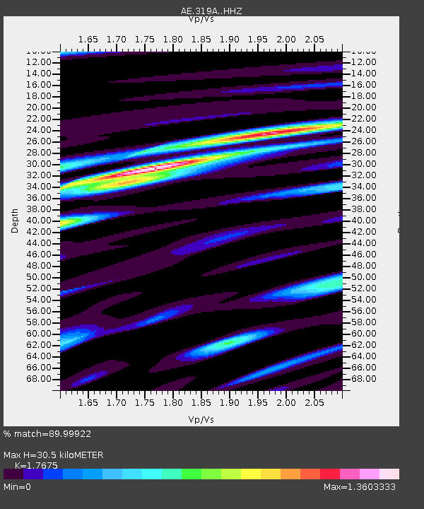
| Estimated Moho Depth: |
30.5 km |
| Estimated Crust Vp/Vs: |
1.77 |
| Assumed Crust Vp: |
6.182 km/s |
| Estimated Crust Vs: |
3.498 km/s |
| Estimated Crust Poisson's Ratio: |
0.26 |
|
| Radial Match: |
89.99922 % |
| Radial Bump: |
400 |
| Transverse Match: |
74.00128 % |
| Transverse Bump: |
400 |
| SOD ConfigId: |
13570011 |
| Insert Time: |
2019-04-28 23:09:38.905 +0000 |
| GWidth: |
2.5 |
| Max Bumps: |
400 |
| Tol: |
0.001 |
|

Signal To Noise
| Channel | StoN | STA | LTA |
| AE:319A: :HHZ:20171008T22:43:32.410012Z | 20.811163 | 3.0462725E-6 | 1.4637685E-7 |
| AE:319A: :HHN:20171008T22:43:32.410012Z | 11.226564 | 1.1560973E-6 | 1.0297872E-7 |
| AE:319A: :HHE:20171008T22:43:32.410012Z | 9.353999 | 1.0842954E-6 | 1.1591784E-7 |
| Arrivals |
| Ps | 4.0 SECOND |
| PpPs | 13 SECOND |
| PsPs/PpSs | 17 SECOND |


