You are here: Home > Network List > AE - Arizona Broadband Seismic Network Stations List
> Station 319A Douglas, AZ, USA > Earthquake Result Viewer
319A Douglas, AZ, USA - Earthquake Result Viewer
| Earthquake location: |
Fox Islands, Aleutian Islands |
| Earthquake latitude/longitude: |
52.6/-167.4 |
| Earthquake time(UTC): |
2012/08/10 (223) 18:37:43 GMT |
| Earthquake Depth: |
13 km |
| Earthquake Magnitude: |
5.9 MB, 6.2 MS, 6.2 MW, 6.2 MW |
| Earthquake Catalog/Contributor: |
WHDF/NEIC |
|
| Network: |
AE Arizona Broadband Seismic Network |
| Station: |
319A Douglas, AZ, USA |
| Lat/Lon: |
31.38 N/109.28 W |
| Elevation: |
1187 m |
|
| Distance: |
46.7 deg |
| Az: |
93.321 deg |
| Baz: |
314.652 deg |
| Ray Param: |
0.07047853 |
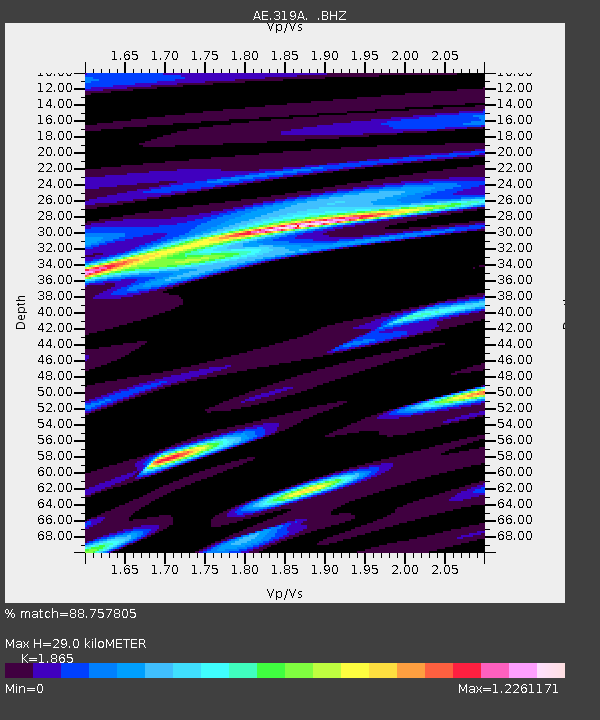
| Estimated Moho Depth: |
29.0 km |
| Estimated Crust Vp/Vs: |
1.87 |
| Assumed Crust Vp: |
6.182 km/s |
| Estimated Crust Vs: |
3.315 km/s |
| Estimated Crust Poisson's Ratio: |
0.30 |
|
| Radial Match: |
88.757805 % |
| Radial Bump: |
400 |
| Transverse Match: |
82.395164 % |
| Transverse Bump: |
400 |
| SOD ConfigId: |
469095 |
| Insert Time: |
2013-02-22 05:33:16.699 +0000 |
| GWidth: |
2.5 |
| Max Bumps: |
400 |
| Tol: |
0.001 |
|

Signal To Noise
| Channel | StoN | STA | LTA |
| AE:319A: :BHZ:20120810T18:45:40.524998Z | 3.6483507 | 2.7571343E-7 | 7.5572075E-8 |
| AE:319A: :BHN:20120810T18:45:40.524998Z | 1.7110972 | 2.5663508E-7 | 1.4998274E-7 |
| AE:319A: :BHE:20120810T18:45:40.524998Z | 1.5490017 | 1.2782532E-7 | 8.25211E-8 |
| Arrivals |
| Ps | 4.3 SECOND |
| PpPs | 13 SECOND |
| PsPs/PpSs | 17 SECOND |


