You are here: Home > Network List > TA - USArray Transportable Network (new EarthScope stations) Stations List
> Station Q61A Milford, DE, USA > Earthquake Result Viewer
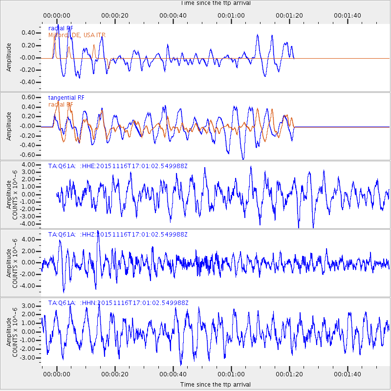
Q61A Milford, DE, USA - Earthquake Result Viewer
*The percent match for this event was below the threshold and hence no stack was calculated.
| Earthquake location: |
Kuril Islands |
| Earthquake latitude/longitude: |
48.3/154.3 |
| Earthquake time(UTC): |
2015/11/16 (320) 16:49:15 GMT |
| Earthquake Depth: |
42 km |
| Earthquake Magnitude: |
5.8 MWB |
| Earthquake Catalog/Contributor: |
NEIC PDE/NEIC COMCAT |
|
| Network: |
TA USArray Transportable Network (new EarthScope stations) |
| Station: |
Q61A Milford, DE, USA |
| Lat/Lon: |
38.88 N/75.33 W |
| Elevation: |
5.0 m |
|
| Distance: |
82.7 deg |
| Az: |
36.812 deg |
| Baz: |
329.16 deg |
| Ray Param: |
$rayparam |
*The percent match for this event was below the threshold and hence was not used in the summary stack. |
|
| Radial Match: |
51.903893 % |
| Radial Bump: |
385 |
| Transverse Match: |
52.21731 % |
| Transverse Bump: |
400 |
| SOD ConfigId: |
7422571 |
| Insert Time: |
2019-04-21 09:37:09.069 +0000 |
| GWidth: |
2.5 |
| Max Bumps: |
400 |
| Tol: |
0.001 |
|
Signal To Noise
| Channel | StoN | STA | LTA |
| TA:Q61A: :HHZ:20151116T17:01:02.549988Z | 3.3125908 | 2.4781152E-6 | 7.480897E-7 |
| TA:Q61A: :HHN:20151116T17:01:02.549988Z | 1.5196747 | 1.7367465E-6 | 1.1428409E-6 |
| TA:Q61A: :HHE:20151116T17:01:02.549988Z | 0.797249 | 1.0438802E-6 | 1.3093527E-6 |
| Arrivals |
| Ps | |
| PpPs | |
| PsPs/PpSs | |


