You are here: Home > Network List > US - United States National Seismic Network Stations List
> Station RSSD Black Hills, South Dakota, USA > Earthquake Result Viewer
RSSD Black Hills, South Dakota, USA - Earthquake Result Viewer
| Earthquake location: |
Near Coast Of Ecuador |
| Earthquake latitude/longitude: |
-2.3/-80.6 |
| Earthquake time(UTC): |
2005/01/24 (024) 06:11:52 GMT |
| Earthquake Depth: |
28 km |
| Earthquake Magnitude: |
5.2 MB, 5.1 MS, 5.6 MW |
| Earthquake Catalog/Contributor: |
WHDF/NEIC |
|
| Network: |
US United States National Seismic Network |
| Station: |
RSSD Black Hills, South Dakota, USA |
| Lat/Lon: |
44.12 N/104.04 W |
| Elevation: |
2060 m |
|
| Distance: |
50.8 deg |
| Az: |
338.339 deg |
| Baz: |
149.197 deg |
| Ray Param: |
0.06778401 |
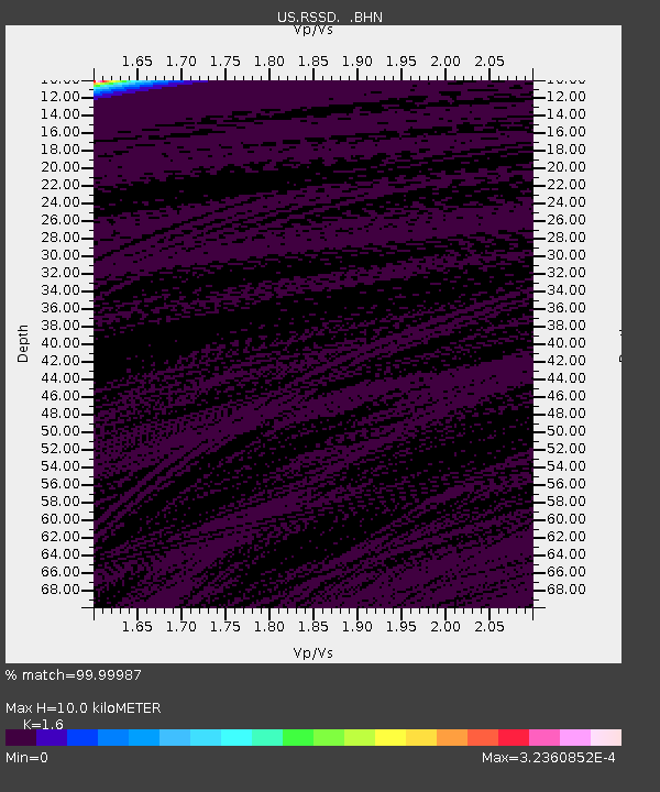
| Estimated Moho Depth: |
10.0 km |
| Estimated Crust Vp/Vs: |
1.60 |
| Assumed Crust Vp: |
6.242 km/s |
| Estimated Crust Vs: |
3.901 km/s |
| Estimated Crust Poisson's Ratio: |
0.18 |
|
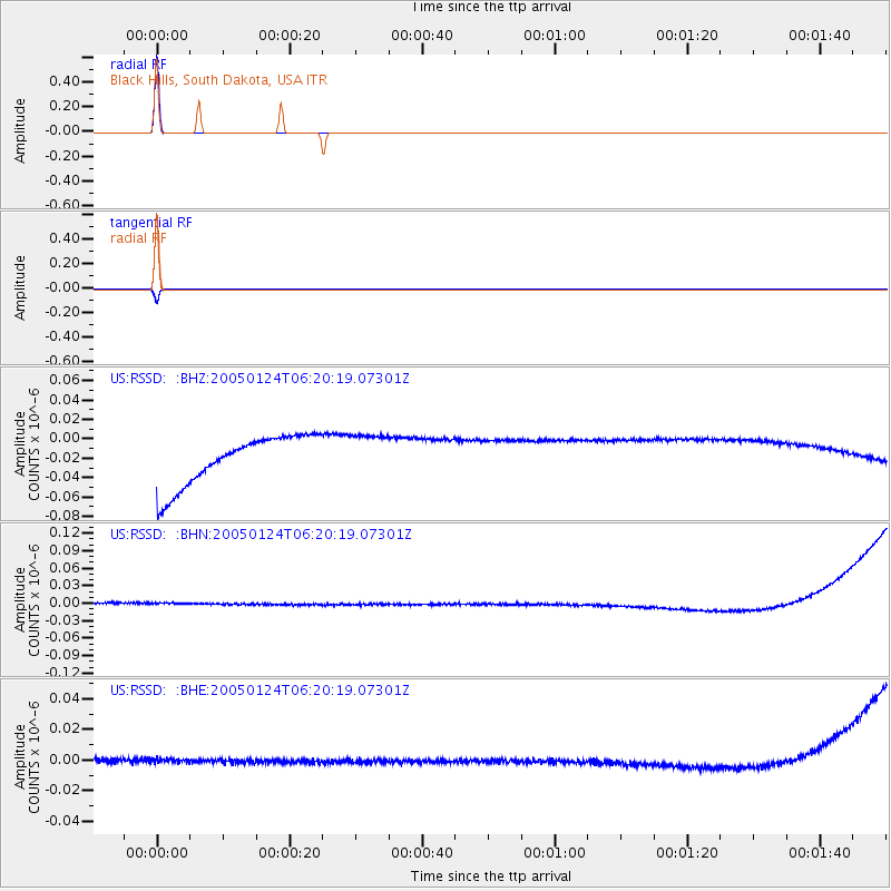
| Radial Match: |
99.99987 % |
| Radial Bump: |
2 |
| Transverse Match: |
99.99656 % |
| Transverse Bump: |
2 |
| SOD ConfigId: |
110165 |
| Insert Time: |
2010-03-05 06:32:07.122 +0000 |
| GWidth: |
2.5 |
| Max Bumps: |
400 |
| Tol: |
0.001 |
|
Signal To Noise
| Channel | StoN | STA | LTA |
| US:RSSD: :BHN:20050124T06:20:19.07301Z | 0.91409624 | 9.8581525E-9 | 1.0784589E-8 |
| US:RSSD: :BHE:20050124T06:20:19.07301Z | 0.92478406 | 3.972652E-9 | 4.2957615E-9 |
| US:RSSD: :BHZ:20050124T06:20:19.07301Z | 0.9014116 | 2.310271E-8 | 2.562948E-8 |
| Arrivals |
| Ps | 1.0 SECOND |
| PpPs | 3.9 SECOND |
| PsPs/PpSs | 4.9 SECOND |


