You are here: Home > Network List > US - United States National Seismic Network Stations List
> Station RSSD Black Hills, South Dakota, USA > Earthquake Result Viewer
RSSD Black Hills, South Dakota, USA - Earthquake Result Viewer
| Earthquake location: |
Near Coast Of Ecuador |
| Earthquake latitude/longitude: |
-1.1/-80.8 |
| Earthquake time(UTC): |
2005/01/21 (021) 13:45:14 GMT |
| Earthquake Depth: |
10 km |
| Earthquake Magnitude: |
5.0 MB, 5.5 MS, 6.0 MW, 6.0 MW |
| Earthquake Catalog/Contributor: |
WHDF/NEIC |
|
| Network: |
US United States National Seismic Network |
| Station: |
RSSD Black Hills, South Dakota, USA |
| Lat/Lon: |
44.12 N/104.04 W |
| Elevation: |
2060 m |
|
| Distance: |
49.6 deg |
| Az: |
338.118 deg |
| Baz: |
148.844 deg |
| Ray Param: |
0.068599835 |
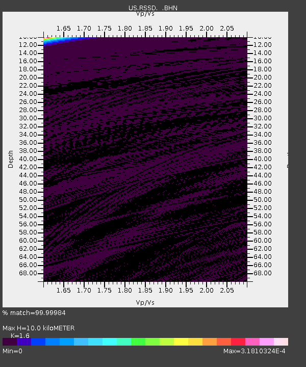
| Estimated Moho Depth: |
10.0 km |
| Estimated Crust Vp/Vs: |
1.60 |
| Assumed Crust Vp: |
6.242 km/s |
| Estimated Crust Vs: |
3.901 km/s |
| Estimated Crust Poisson's Ratio: |
0.18 |
|
| Radial Match: |
99.99984 % |
| Radial Bump: |
2 |
| Transverse Match: |
99.99549 % |
| Transverse Bump: |
2 |
| SOD ConfigId: |
110165 |
| Insert Time: |
2010-03-05 06:32:07.844 +0000 |
| GWidth: |
2.5 |
| Max Bumps: |
400 |
| Tol: |
0.001 |
|
Signal To Noise
| Channel | StoN | STA | LTA |
| US:RSSD: :BHN:20050121T13:53:34.372012Z | 0.9205395 | 1.00655395E-8 | 1.0934392E-8 |
| US:RSSD: :BHE:20050121T13:53:34.372012Z | 0.883785 | 3.7518784E-9 | 4.245239E-9 |
| US:RSSD: :BHZ:20050121T13:53:34.372012Z | 0.92416877 | 2.362021E-8 | 2.5558329E-8 |
| Arrivals |
| Ps | 1.0 SECOND |
| PpPs | 3.9 SECOND |
| PsPs/PpSs | 4.9 SECOND |


