You are here: Home > Network List > US - United States National Seismic Network Stations List
> Station RSSD Black Hills, South Dakota, USA > Earthquake Result Viewer
RSSD Black Hills, South Dakota, USA - Earthquake Result Viewer
| Earthquake location: |
Samoa Islands Region |
| Earthquake latitude/longitude: |
-16.6/-172.0 |
| Earthquake time(UTC): |
2006/09/28 (271) 06:22:09 GMT |
| Earthquake Depth: |
28 km |
| Earthquake Magnitude: |
6.5 MB, 6.6 MS, 6.9 MW, 6.7 MW |
| Earthquake Catalog/Contributor: |
WHDF/NEIC |
|
| Network: |
US United States National Seismic Network |
| Station: |
RSSD Black Hills, South Dakota, USA |
| Lat/Lon: |
44.12 N/104.04 W |
| Elevation: |
2060 m |
|
| Distance: |
86.5 deg |
| Az: |
41.993 deg |
| Baz: |
242.967 deg |
| Ray Param: |
0.04400815 |
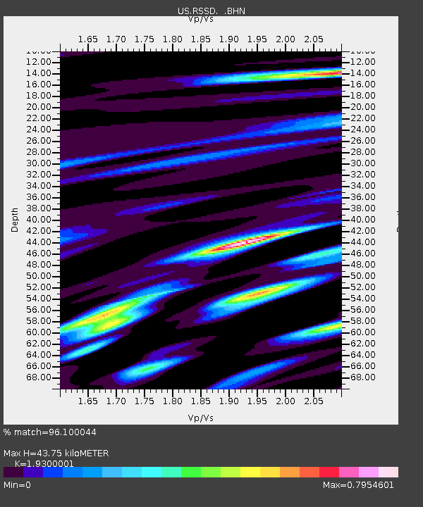
| Estimated Moho Depth: |
43.75 km |
| Estimated Crust Vp/Vs: |
1.93 |
| Assumed Crust Vp: |
6.242 km/s |
| Estimated Crust Vs: |
3.234 km/s |
| Estimated Crust Poisson's Ratio: |
0.32 |
|
| Radial Match: |
96.100044 % |
| Radial Bump: |
367 |
| Transverse Match: |
89.09159 % |
| Transverse Bump: |
398 |
| SOD ConfigId: |
2665 |
| Insert Time: |
2010-03-05 06:32:13.202 +0000 |
| GWidth: |
2.5 |
| Max Bumps: |
400 |
| Tol: |
0.001 |
|
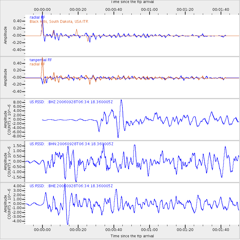
Signal To Noise
| Channel | StoN | STA | LTA |
| US:RSSD: :BHN:20060928T06:34:18.360005Z | 4.2195964 | 4.5002776E-7 | 1.0665185E-7 |
| US:RSSD: :BHE:20060928T06:34:18.360005Z | 8.251675 | 1.141386E-6 | 1.3832174E-7 |
| US:RSSD: :BHZ:20060928T06:34:18.360005Z | 13.314271 | 2.3756395E-6 | 1.7842805E-7 |
| Arrivals |
| Ps | 6.7 SECOND |
| PpPs | 20 SECOND |
| PsPs/PpSs | 27 SECOND |


