You are here: Home > Network List > US - United States National Seismic Network Stations List
> Station RSSD Black Hills, South Dakota, USA > Earthquake Result Viewer
RSSD Black Hills, South Dakota, USA - Earthquake Result Viewer
| Earthquake location: |
Panama-Colombia Border Region |
| Earthquake latitude/longitude: |
7.0/-77.8 |
| Earthquake time(UTC): |
2000/11/08 (313) 06:59:58 GMT |
| Earthquake Depth: |
17 km |
| Earthquake Magnitude: |
6.0 MB, 6.4 MS, 6.5 MW, 6.2 ML |
| Earthquake Catalog/Contributor: |
WHDF/NEIC |
|
| Network: |
US United States National Seismic Network |
| Station: |
RSSD Black Hills, South Dakota, USA |
| Lat/Lon: |
44.12 N/104.04 W |
| Elevation: |
2060 m |
|
| Distance: |
43.5 deg |
| Az: |
332.458 deg |
| Baz: |
140.413 deg |
| Ray Param: |
0.07251971 |
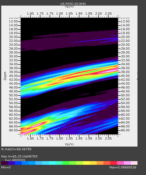
| Estimated Moho Depth: |
65.25 km |
| Estimated Crust Vp/Vs: |
1.68 |
| Assumed Crust Vp: |
6.242 km/s |
| Estimated Crust Vs: |
3.715 km/s |
| Estimated Crust Poisson's Ratio: |
0.23 |
|
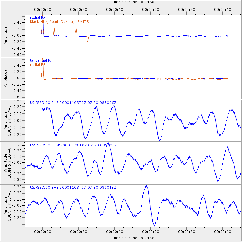
| Radial Match: |
86.46798 % |
| Radial Bump: |
164 |
| Transverse Match: |
19.265467 % |
| Transverse Bump: |
272 |
| SOD ConfigId: |
110165 |
| Insert Time: |
2010-03-05 06:32:14.275 +0000 |
| GWidth: |
2.5 |
| Max Bumps: |
400 |
| Tol: |
0.001 |
|
Signal To Noise
| Channel | StoN | STA | LTA |
| US:RSSD:00:BHN:20001108T07:07:30.085006Z | 0.6449194 | 7.6356464E-8 | 1.1839692E-7 |
| US:RSSD:00:BHE:20001108T07:07:30.086013Z | 0.93527853 | 8.691153E-8 | 9.292582E-8 |
| US:RSSD:00:BHZ:20001108T07:07:30.085006Z | 1.1015292 | 1.504436E-7 | 1.3657703E-7 |
| Arrivals |
| Ps | 7.6 SECOND |
| PpPs | 26 SECOND |
| PsPs/PpSs | 34 SECOND |


