You are here: Home > Network List > US - United States National Seismic Network Stations List
> Station RSSD Black Hills, South Dakota, USA > Earthquake Result Viewer
RSSD Black Hills, South Dakota, USA - Earthquake Result Viewer
| Earthquake location: |
Near Coast Of Ecuador |
| Earthquake latitude/longitude: |
-0.2/-80.6 |
| Earthquake time(UTC): |
2000/09/28 (272) 23:23:43 GMT |
| Earthquake Depth: |
23 km |
| Earthquake Magnitude: |
5.8 MB, 6.0 MS, 6.6 MW, 6.4 MW |
| Earthquake Catalog/Contributor: |
WHDF/NEIC |
|
| Network: |
US United States National Seismic Network |
| Station: |
RSSD Black Hills, South Dakota, USA |
| Lat/Lon: |
44.12 N/104.04 W |
| Elevation: |
2060 m |
|
| Distance: |
48.8 deg |
| Az: |
337.621 deg |
| Baz: |
148.087 deg |
| Ray Param: |
0.06905572 |
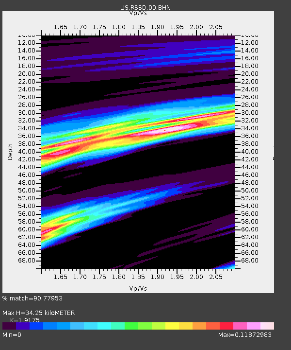
| Estimated Moho Depth: |
34.25 km |
| Estimated Crust Vp/Vs: |
1.92 |
| Assumed Crust Vp: |
6.242 km/s |
| Estimated Crust Vs: |
3.255 km/s |
| Estimated Crust Poisson's Ratio: |
0.31 |
|
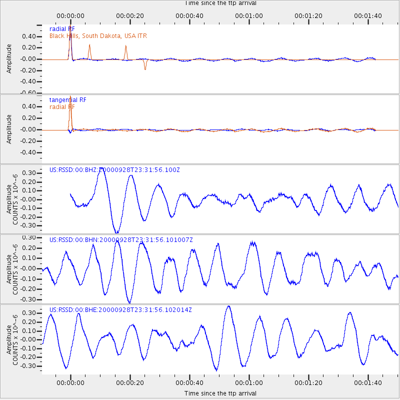
| Radial Match: |
90.77953 % |
| Radial Bump: |
216 |
| Transverse Match: |
13.769811 % |
| Transverse Bump: |
261 |
| SOD ConfigId: |
110165 |
| Insert Time: |
2010-03-05 06:32:20.890 +0000 |
| GWidth: |
2.5 |
| Max Bumps: |
400 |
| Tol: |
0.001 |
|
Signal To Noise
| Channel | StoN | STA | LTA |
| US:RSSD:00:BHN:20000928T23:31:56.101007Z | 1.4101745 | 9.899885E-8 | 7.0203264E-8 |
| US:RSSD:00:BHE:20000928T23:31:56.102014Z | 1.3047205 | 1.8998206E-7 | 1.4561131E-7 |
| US:RSSD:00:BHZ:20000928T23:31:56.100Z | 0.6959669 | 1.3989394E-7 | 2.010066E-7 |
| Arrivals |
| Ps | 5.3 SECOND |
| PpPs | 15 SECOND |
| PsPs/PpSs | 21 SECOND |


