You are here: Home > Network List > US - United States National Seismic Network Stations List
> Station RSSD Black Hills, South Dakota, USA > Earthquake Result Viewer
RSSD Black Hills, South Dakota, USA - Earthquake Result Viewer
| Earthquake location: |
Southern Greece |
| Earthquake latitude/longitude: |
36.0/22.0 |
| Earthquake time(UTC): |
2000/05/24 (145) 05:40:37 GMT |
| Earthquake Depth: |
33 km |
| Earthquake Magnitude: |
5.3 MB, 5.6 MS, 5.9 MW, 5.7 MW |
| Earthquake Catalog/Contributor: |
WHDF/NEIC |
|
| Network: |
US United States National Seismic Network |
| Station: |
RSSD Black Hills, South Dakota, USA |
| Lat/Lon: |
44.12 N/104.04 W |
| Elevation: |
2060 m |
|
| Distance: |
86.4 deg |
| Az: |
324.305 deg |
| Baz: |
41.039 deg |
| Ray Param: |
0.044041935 |
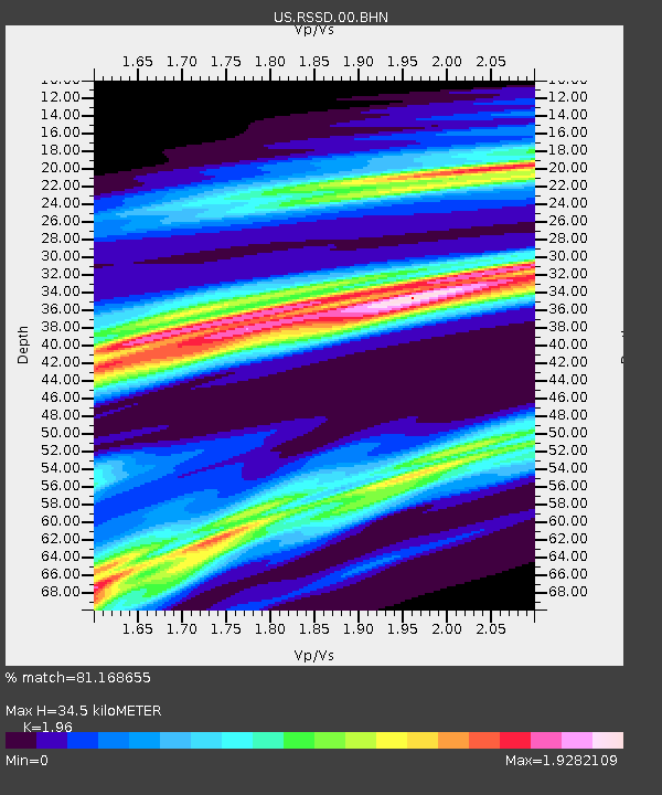
| Estimated Moho Depth: |
34.5 km |
| Estimated Crust Vp/Vs: |
1.96 |
| Assumed Crust Vp: |
6.242 km/s |
| Estimated Crust Vs: |
3.185 km/s |
| Estimated Crust Poisson's Ratio: |
0.32 |
|
| Radial Match: |
81.168655 % |
| Radial Bump: |
362 |
| Transverse Match: |
43.299667 % |
| Transverse Bump: |
390 |
| SOD ConfigId: |
110165 |
| Insert Time: |
2010-03-05 06:32:22.104 +0000 |
| GWidth: |
2.5 |
| Max Bumps: |
400 |
| Tol: |
0.001 |
|
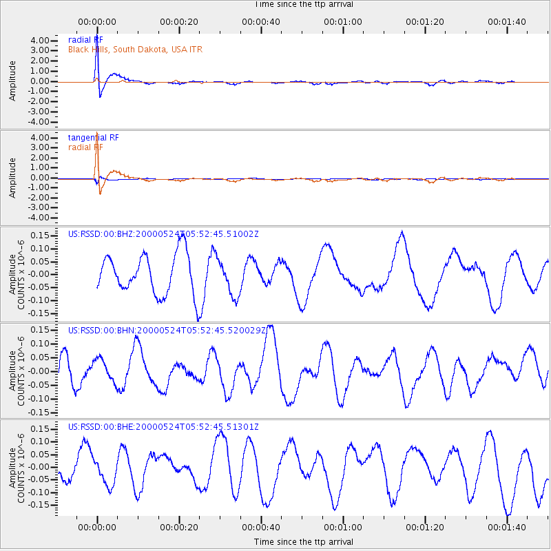
Signal To Noise
| Channel | StoN | STA | LTA |
| US:RSSD:00:BHN:20000524T05:52:45.520029Z | 0.6909002 | 4.330963E-8 | 6.26858E-8 |
| US:RSSD:00:BHE:20000524T05:52:45.51301Z | 1.054282 | 5.266621E-8 | 4.995458E-8 |
| US:RSSD:00:BHZ:20000524T05:52:45.51002Z | 0.92152935 | 7.11842E-8 | 7.724572E-8 |
| Arrivals |
| Ps | 5.4 SECOND |
| PpPs | 16 SECOND |
| PsPs/PpSs | 21 SECOND |


