You are here: Home > Network List > US - United States National Seismic Network Stations List
> Station RSSD Black Hills, South Dakota, USA > Earthquake Result Viewer
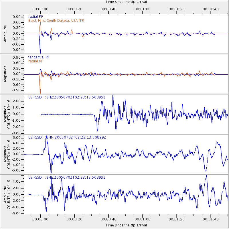
RSSD Black Hills, South Dakota, USA - Earthquake Result Viewer
*The percent match for this event was below the threshold and hence no stack was calculated.
| Earthquake location: |
Near Coast Of Nicaragua |
| Earthquake latitude/longitude: |
11.2/-86.2 |
| Earthquake time(UTC): |
2005/07/02 (183) 02:16:43 GMT |
| Earthquake Depth: |
27 km |
| Earthquake Magnitude: |
5.6 MB, 6.4 MS, 6.6 MW, 6.6 MW |
| Earthquake Catalog/Contributor: |
WHDF/NEIC |
|
| Network: |
US United States National Seismic Network |
| Station: |
RSSD Black Hills, South Dakota, USA |
| Lat/Lon: |
44.12 N/104.04 W |
| Elevation: |
2060 m |
|
| Distance: |
36.2 deg |
| Az: |
338.035 deg |
| Baz: |
149.37 deg |
| Ray Param: |
$rayparam |
*The percent match for this event was below the threshold and hence was not used in the summary stack. |
|
| Radial Match: |
85.48853 % |
| Radial Bump: |
278 |
| Transverse Match: |
80.69553 % |
| Transverse Bump: |
400 |
| SOD ConfigId: |
3128 |
| Insert Time: |
2010-03-05 06:32:57.092 +0000 |
| GWidth: |
2.5 |
| Max Bumps: |
400 |
| Tol: |
0.001 |
|
Signal To Noise
| Channel | StoN | STA | LTA |
| US:RSSD: :BHN:20050702T02:23:13.50899Z | 55.8486 | 3.0002338E-6 | 5.3720843E-8 |
| US:RSSD: :BHE:20050702T02:23:13.50899Z | 38.3705 | 1.8942267E-6 | 4.9366747E-8 |
| US:RSSD: :BHZ:20050702T02:23:13.50899Z | 33.670055 | 9.594705E-7 | 2.8496254E-8 |
| Arrivals |
| Ps | |
| PpPs | |
| PsPs/PpSs | |


