You are here: Home > Network List > GE - GEOFON Stations List
> Station UGM GEOFON Station Wanagama, Indonesia > Earthquake Result Viewer
UGM GEOFON Station Wanagama, Indonesia - Earthquake Result Viewer
| Earthquake location: |
Kermadec Islands Region |
| Earthquake latitude/longitude: |
-31.2/-176.9 |
| Earthquake time(UTC): |
2008/12/09 (344) 06:23:59 GMT |
| Earthquake Depth: |
18 km |
| Earthquake Magnitude: |
6.2 MB, 6.7 MS, 6.8 MW, 6.7 MW |
| Earthquake Catalog/Contributor: |
WHDF/NEIC |
|
| Network: |
GE GEOFON |
| Station: |
UGM GEOFON Station Wanagama, Indonesia |
| Lat/Lon: |
7.91 S/110.52 E |
| Elevation: |
350 m |
|
| Distance: |
71.0 deg |
| Az: |
272.187 deg |
| Baz: |
120.219 deg |
| Ray Param: |
0.054570787 |
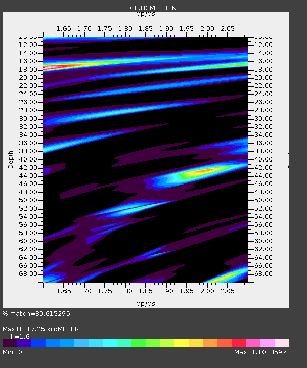
| Estimated Moho Depth: |
17.25 km |
| Estimated Crust Vp/Vs: |
1.60 |
| Assumed Crust Vp: |
6.343 km/s |
| Estimated Crust Vs: |
3.965 km/s |
| Estimated Crust Poisson's Ratio: |
0.18 |
|
| Radial Match: |
80.615295 % |
| Radial Bump: |
400 |
| Transverse Match: |
71.40911 % |
| Transverse Bump: |
399 |
| SOD ConfigId: |
2658 |
| Insert Time: |
2010-03-09 05:10:00.773 +0000 |
| GWidth: |
2.5 |
| Max Bumps: |
400 |
| Tol: |
0.001 |
|
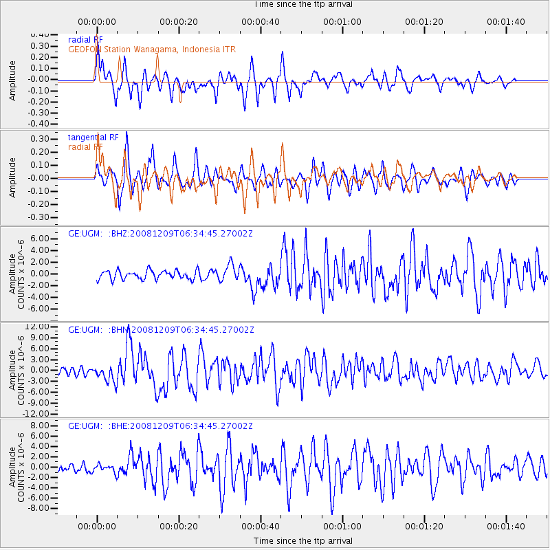
Signal To Noise
| Channel | StoN | STA | LTA |
| GE:UGM: :BHN:20081209T06:34:45.27002Z | 2.7049387 | 2.3344182E-6 | 8.630208E-7 |
| GE:UGM: :BHE:20081209T06:34:45.27002Z | 1.3816451 | 7.459648E-7 | 5.3991056E-7 |
| GE:UGM: :BHZ:20081209T06:34:45.27002Z | 1.8964179 | 1.3966973E-6 | 7.364923E-7 |
| Arrivals |
| Ps | 1.7 SECOND |
| PpPs | 6.8 SECOND |
| PsPs/PpSs | 8.5 SECOND |


