You are here: Home > Network List > GE - GEOFON Stations List
> Station UGM GEOFON Station Wanagama, Indonesia > Earthquake Result Viewer
UGM GEOFON Station Wanagama, Indonesia - Earthquake Result Viewer
| Earthquake location: |
Turkmenistan |
| Earthquake latitude/longitude: |
39.6/54.8 |
| Earthquake time(UTC): |
2000/12/06 (341) 17:11:06 GMT |
| Earthquake Depth: |
30 km |
| Earthquake Magnitude: |
6.7 MB, 7.5 MS, 7.0 MW, 6.9 ME |
| Earthquake Catalog/Contributor: |
WHDF/NEIC |
|
| Network: |
GE GEOFON |
| Station: |
UGM GEOFON Station Wanagama, Indonesia |
| Lat/Lon: |
7.91 S/110.52 E |
| Elevation: |
350 m |
|
| Distance: |
69.9 deg |
| Az: |
119.315 deg |
| Baz: |
317.126 deg |
| Ray Param: |
0.055329375 |
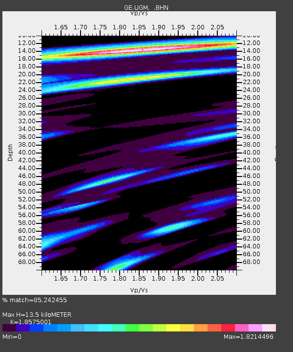
| Estimated Moho Depth: |
13.5 km |
| Estimated Crust Vp/Vs: |
1.86 |
| Assumed Crust Vp: |
6.343 km/s |
| Estimated Crust Vs: |
3.415 km/s |
| Estimated Crust Poisson's Ratio: |
0.30 |
|
| Radial Match: |
85.242455 % |
| Radial Bump: |
400 |
| Transverse Match: |
74.24229 % |
| Transverse Bump: |
400 |
| SOD ConfigId: |
3744 |
| Insert Time: |
2010-03-09 05:10:04.940 +0000 |
| GWidth: |
2.5 |
| Max Bumps: |
400 |
| Tol: |
0.001 |
|
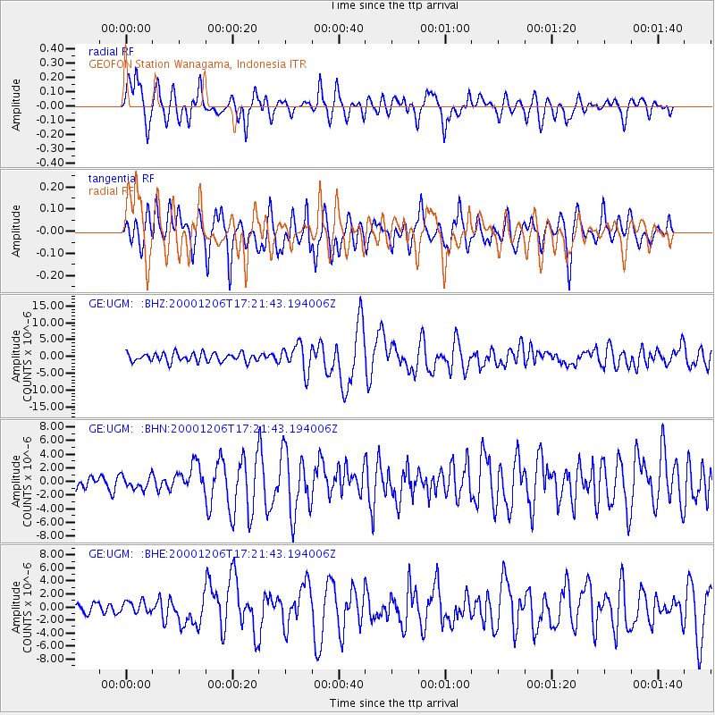
Signal To Noise
| Channel | StoN | STA | LTA |
| GE:UGM: :BHN:20001206T17:21:43.194006Z | 0.8551487 | 9.344189E-7 | 1.0926976E-6 |
| GE:UGM: :BHE:20001206T17:21:43.194006Z | 1.0238221 | 9.0586167E-7 | 8.847843E-7 |
| GE:UGM: :BHZ:20001206T17:21:43.194006Z | 3.14589 | 4.055194E-6 | 1.2890451E-6 |
| Arrivals |
| Ps | 1.9 SECOND |
| PpPs | 5.9 SECOND |
| PsPs/PpSs | 7.8 SECOND |


