You are here: Home > Network List > GE - GEOFON Stations List
> Station UGM GEOFON Station Wanagama, Indonesia > Earthquake Result Viewer
UGM GEOFON Station Wanagama, Indonesia - Earthquake Result Viewer
| Earthquake location: |
Taiwan Region |
| Earthquake latitude/longitude: |
24.0/122.7 |
| Earthquake time(UTC): |
2001/12/18 (352) 04:02:58 GMT |
| Earthquake Depth: |
14 km |
| Earthquake Magnitude: |
6.3 MB, 7.3 MS, 6.9 MW, 6.8 MW |
| Earthquake Catalog/Contributor: |
WHDF/NEIC |
|
| Network: |
GE GEOFON |
| Station: |
UGM GEOFON Station Wanagama, Indonesia |
| Lat/Lon: |
7.91 S/110.52 E |
| Elevation: |
350 m |
|
| Distance: |
33.8 deg |
| Az: |
202.1 deg |
| Baz: |
20.332 deg |
| Ray Param: |
0.07801261 |
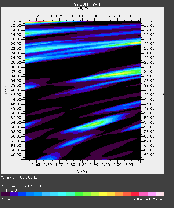
| Estimated Moho Depth: |
10.0 km |
| Estimated Crust Vp/Vs: |
1.60 |
| Assumed Crust Vp: |
6.343 km/s |
| Estimated Crust Vs: |
3.965 km/s |
| Estimated Crust Poisson's Ratio: |
0.18 |
|
| Radial Match: |
85.78641 % |
| Radial Bump: |
343 |
| Transverse Match: |
79.00908 % |
| Transverse Bump: |
400 |
| SOD ConfigId: |
20082 |
| Insert Time: |
2010-03-09 05:10:13.232 +0000 |
| GWidth: |
2.5 |
| Max Bumps: |
400 |
| Tol: |
0.001 |
|
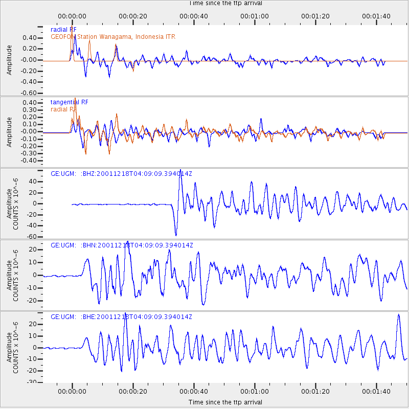
Signal To Noise
| Channel | StoN | STA | LTA |
| GE:UGM: :BHN:20011218T04:09:09.394014Z | 14.039639 | 4.8581214E-6 | 3.460289E-7 |
| GE:UGM: :BHE:20011218T04:09:09.394014Z | 9.370296 | 3.414814E-6 | 3.644297E-7 |
| GE:UGM: :BHZ:20011218T04:09:09.394014Z | 43.467587 | 2.0615624E-5 | 4.742758E-7 |
| Arrivals |
| Ps | 1.0 SECOND |
| PpPs | 3.8 SECOND |
| PsPs/PpSs | 4.8 SECOND |


