You are here: Home > Network List > GE - GEOFON Stations List
> Station UGM GEOFON Station Wanagama, Indonesia > Earthquake Result Viewer
UGM GEOFON Station Wanagama, Indonesia - Earthquake Result Viewer
| Earthquake location: |
Ryukyu Islands, Japan |
| Earthquake latitude/longitude: |
28.3/129.6 |
| Earthquake time(UTC): |
2001/12/08 (342) 20:29:34 GMT |
| Earthquake Depth: |
33 km |
| Earthquake Magnitude: |
5.7 MB, 5.7 MS, 6.2 MW, 6.1 MW |
| Earthquake Catalog/Contributor: |
WHDF/NEIC |
|
| Network: |
GE GEOFON |
| Station: |
UGM GEOFON Station Wanagama, Indonesia |
| Lat/Lon: |
7.91 S/110.52 E |
| Elevation: |
350 m |
|
| Distance: |
40.4 deg |
| Az: |
209.934 deg |
| Baz: |
26.384 deg |
| Ray Param: |
0.07436704 |
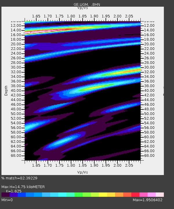
| Estimated Moho Depth: |
14.75 km |
| Estimated Crust Vp/Vs: |
1.62 |
| Assumed Crust Vp: |
6.343 km/s |
| Estimated Crust Vs: |
3.904 km/s |
| Estimated Crust Poisson's Ratio: |
0.20 |
|
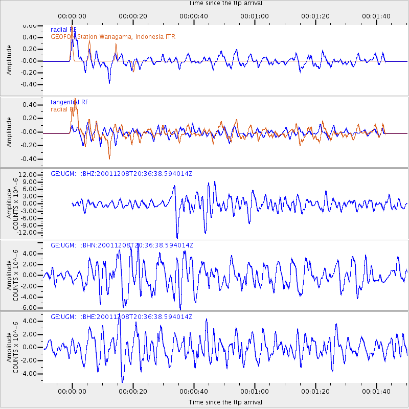
| Radial Match: |
82.39229 % |
| Radial Bump: |
400 |
| Transverse Match: |
63.99649 % |
| Transverse Bump: |
390 |
| SOD ConfigId: |
20082 |
| Insert Time: |
2010-03-09 05:10:14.367 +0000 |
| GWidth: |
2.5 |
| Max Bumps: |
400 |
| Tol: |
0.001 |
|
Signal To Noise
| Channel | StoN | STA | LTA |
| GE:UGM: :BHN:20011208T20:36:38.594014Z | 1.3144643 | 1.1359734E-6 | 8.6421016E-7 |
| GE:UGM: :BHE:20011208T20:36:38.594014Z | 1.9965355 | 1.317141E-6 | 6.597133E-7 |
| GE:UGM: :BHZ:20011208T20:36:38.594014Z | 4.606256 | 5.288745E-6 | 1.1481657E-6 |
| Arrivals |
| Ps | 1.6 SECOND |
| PpPs | 5.7 SECOND |
| PsPs/PpSs | 7.2 SECOND |


