You are here: Home > Network List > GE - GEOFON Stations List
> Station UGM GEOFON Station Wanagama, Indonesia > Earthquake Result Viewer
UGM GEOFON Station Wanagama, Indonesia - Earthquake Result Viewer
| Earthquake location: |
Taiwan Region |
| Earthquake latitude/longitude: |
24.3/122.2 |
| Earthquake time(UTC): |
2002/03/31 (090) 06:52:50 GMT |
| Earthquake Depth: |
33 km |
| Earthquake Magnitude: |
6.4 MB, 7.4 MS, 7.1 MW, 7.1 MW |
| Earthquake Catalog/Contributor: |
WHDF/NEIC |
|
| Network: |
GE GEOFON |
| Station: |
UGM GEOFON Station Wanagama, Indonesia |
| Lat/Lon: |
7.91 S/110.52 E |
| Elevation: |
350 m |
|
| Distance: |
34.0 deg |
| Az: |
200.995 deg |
| Baz: |
19.273 deg |
| Ray Param: |
0.07791571 |
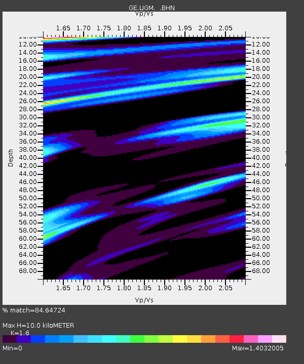
| Estimated Moho Depth: |
10.0 km |
| Estimated Crust Vp/Vs: |
1.60 |
| Assumed Crust Vp: |
6.343 km/s |
| Estimated Crust Vs: |
3.965 km/s |
| Estimated Crust Poisson's Ratio: |
0.18 |
|
| Radial Match: |
84.64724 % |
| Radial Bump: |
400 |
| Transverse Match: |
80.889946 % |
| Transverse Bump: |
400 |
| SOD ConfigId: |
20082 |
| Insert Time: |
2010-03-09 05:10:28.048 +0000 |
| GWidth: |
2.5 |
| Max Bumps: |
400 |
| Tol: |
0.001 |
|
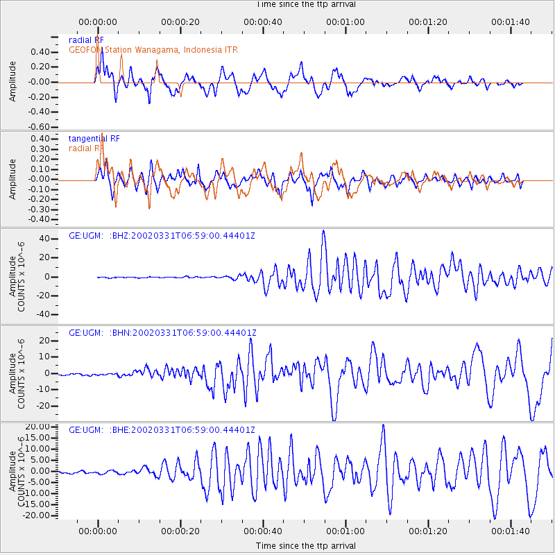
Signal To Noise
| Channel | StoN | STA | LTA |
| GE:UGM: :BHN:20020331T06:59:00.44401Z | 0.881548 | 3.2477533E-7 | 3.6841482E-7 |
| GE:UGM: :BHE:20020331T06:59:00.44401Z | 1.9447842 | 6.7736306E-7 | 3.482973E-7 |
| GE:UGM: :BHZ:20020331T06:59:00.44401Z | 3.6659284 | 1.7102668E-6 | 4.6653034E-7 |
| Arrivals |
| Ps | 1.0 SECOND |
| PpPs | 3.8 SECOND |
| PsPs/PpSs | 4.8 SECOND |


