UGM GEOFON Station Wanagama, Indonesia - Earthquake Result Viewer
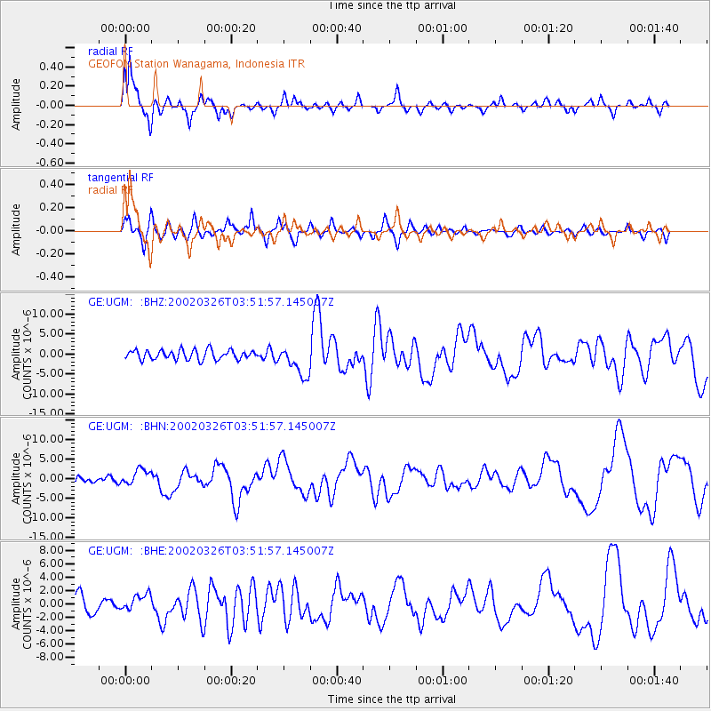
Earthquake location: Southwestern Ryukyu Isl., Japan
Earthquake latitude/longitude: 23.3/124.1
Earthquake time(UTC): 2002/03/26 (085) 03:45:48 GMT
Earthquake Depth: 33 km
Earthquake Magnitude: 5.8 MB, 6.6 MS, 6.4 MW, 6.4 MW
Earthquake Catalog/Contributor: WHDF/NEIC
Network: GE GEOFON
Station: UGM GEOFON Station Wanagama, Indonesia
Lat/Lon: 7.91 S/110.52 E
Elevation: 350 m
Distance: 33.8 deg
Az: 204.704 deg
Baz: 22.815 deg
Ray Param: 0.0779963
Estimated Moho Depth: 10.5 km
Estimated Crust Vp/Vs: 1.60
Assumed Crust Vp: 6.343 km/s
Estimated Crust Vs: 3.965 km/s
Estimated Crust Poisson's Ratio: 0.18
Radial Match: 82.25549 %
Radial Bump: 366
Transverse Match: 76.831535 %
Transverse Bump: 354
SOD ConfigId: 20082
Insert Time: 2010-03-09 05:10:29.413 +0000
GWidth: 2.5
Max Bumps: 400
Tol: 0.001

Signal To Noise

ChannelStoNSTALTA
GE:UGM: :BHN:20020326T03:51:57.145007Z2.86154032.0125665E-67.033158E-7
GE:UGM: :BHE:20020326T03:51:57.145007Z1.19317351.2842169E-61.0763035E-6
GE:UGM: :BHZ:20020326T03:51:57.145007Z3.23699833.857947E-61.1918286E-6
Arrivals
Ps1.1 SECOND
PpPs4.0 SECOND
PsPs/PpSs5.0 SECOND