You are here: Home > Network List > GE - GEOFON Stations List
> Station UGM GEOFON Station Wanagama, Indonesia > Earthquake Result Viewer
UGM GEOFON Station Wanagama, Indonesia - Earthquake Result Viewer
| Earthquake location: |
Macquarie Island Region |
| Earthquake latitude/longitude: |
-55.7/158.5 |
| Earthquake time(UTC): |
2008/04/12 (103) 00:30:12 GMT |
| Earthquake Depth: |
16 km |
| Earthquake Magnitude: |
6.8 MB, 7.1 MS, 7.1 MW, 7.1 MW |
| Earthquake Catalog/Contributor: |
WHDF/NEIC |
|
| Network: |
GE GEOFON |
| Station: |
UGM GEOFON Station Wanagama, Indonesia |
| Lat/Lon: |
7.91 S/110.52 E |
| Elevation: |
350 m |
|
| Distance: |
60.7 deg |
| Az: |
302.552 deg |
| Baz: |
151.175 deg |
| Ray Param: |
0.061319415 |
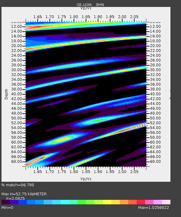
| Estimated Moho Depth: |
52.75 km |
| Estimated Crust Vp/Vs: |
2.08 |
| Assumed Crust Vp: |
6.343 km/s |
| Estimated Crust Vs: |
3.046 km/s |
| Estimated Crust Poisson's Ratio: |
0.35 |
|
| Radial Match: |
86.798 % |
| Radial Bump: |
313 |
| Transverse Match: |
81.774254 % |
| Transverse Bump: |
400 |
| SOD ConfigId: |
2504 |
| Insert Time: |
2010-03-09 05:10:38.210 +0000 |
| GWidth: |
2.5 |
| Max Bumps: |
400 |
| Tol: |
0.001 |
|
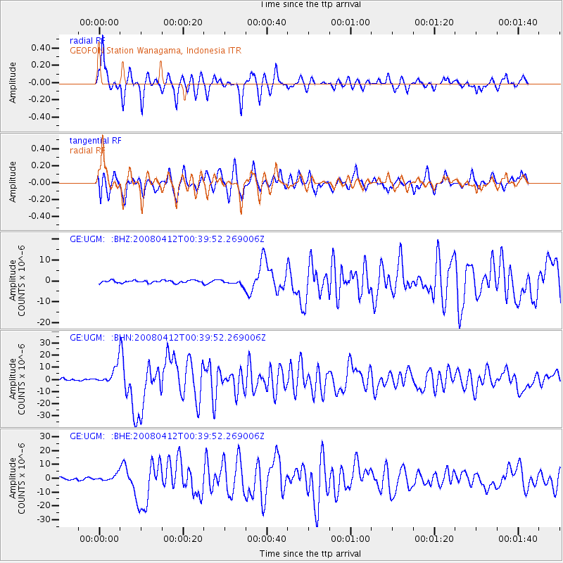
Signal To Noise
| Channel | StoN | STA | LTA |
| GE:UGM: :BHN:20080412T00:39:52.269006Z | 9.957767 | 8.077737E-6 | 8.111997E-7 |
| GE:UGM: :BHE:20080412T00:39:52.269006Z | 3.4418092 | 2.487136E-6 | 7.226246E-7 |
| GE:UGM: :BHZ:20080412T00:39:52.269006Z | 2.312951 | 1.3812627E-6 | 5.971863E-7 |
| Arrivals |
| Ps | 9.4 SECOND |
| PpPs | 25 SECOND |
| PsPs/PpSs | 34 SECOND |


