You are here: Home > Network List > GE - GEOFON Stations List
> Station UGM GEOFON Station Wanagama, Indonesia > Earthquake Result Viewer
UGM GEOFON Station Wanagama, Indonesia - Earthquake Result Viewer
| Earthquake location: |
Vanuatu Islands |
| Earthquake latitude/longitude: |
-13.5/167.0 |
| Earthquake time(UTC): |
2008/09/08 (252) 18:52:06 GMT |
| Earthquake Depth: |
110 km |
| Earthquake Magnitude: |
6.4 MB, 6.9 MW, 6.9 MW |
| Earthquake Catalog/Contributor: |
WHDF/NEIC |
|
| Network: |
GE GEOFON |
| Station: |
UGM GEOFON Station Wanagama, Indonesia |
| Lat/Lon: |
7.91 S/110.52 E |
| Elevation: |
350 m |
|
| Distance: |
55.6 deg |
| Az: |
269.584 deg |
| Baz: |
100.912 deg |
| Ray Param: |
0.064322285 |
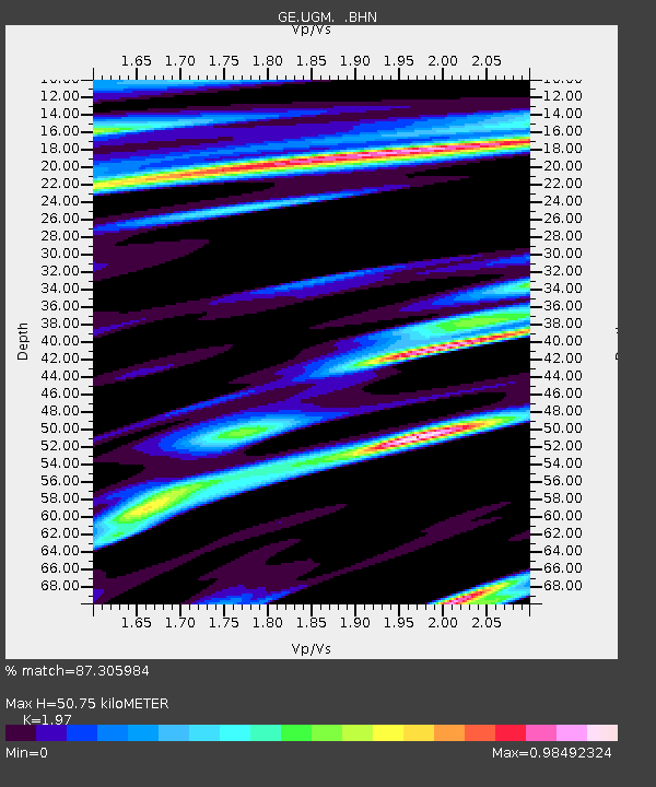
| Estimated Moho Depth: |
50.75 km |
| Estimated Crust Vp/Vs: |
1.97 |
| Assumed Crust Vp: |
6.343 km/s |
| Estimated Crust Vs: |
3.22 km/s |
| Estimated Crust Poisson's Ratio: |
0.33 |
|
| Radial Match: |
87.305984 % |
| Radial Bump: |
400 |
| Transverse Match: |
72.58985 % |
| Transverse Bump: |
393 |
| SOD ConfigId: |
2560 |
| Insert Time: |
2010-03-09 05:10:45.731 +0000 |
| GWidth: |
2.5 |
| Max Bumps: |
400 |
| Tol: |
0.001 |
|

Signal To Noise
| Channel | StoN | STA | LTA |
| GE:UGM: :BHN:20080908T19:01:00.920012Z | 28.802748 | 2.271737E-5 | 7.887223E-7 |
| GE:UGM: :BHE:20080908T19:01:00.920012Z | 3.0367093 | 3.930812E-6 | 1.2944314E-6 |
| GE:UGM: :BHZ:20080908T19:01:00.920012Z | 5.534438 | 6.475254E-6 | 1.1699931E-6 |
| Arrivals |
| Ps | 8.1 SECOND |
| PpPs | 23 SECOND |
| PsPs/PpSs | 31 SECOND |


