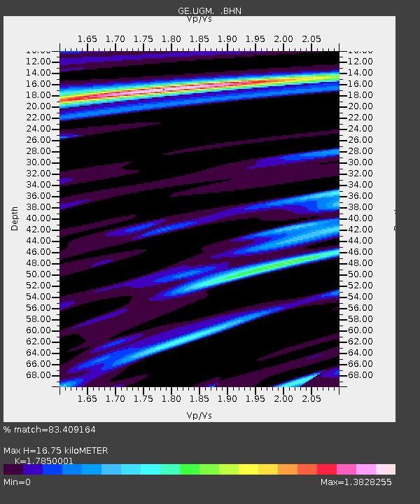
UGM GEOFON Station Wanagama, Indonesia - Earthquake Result Viewer
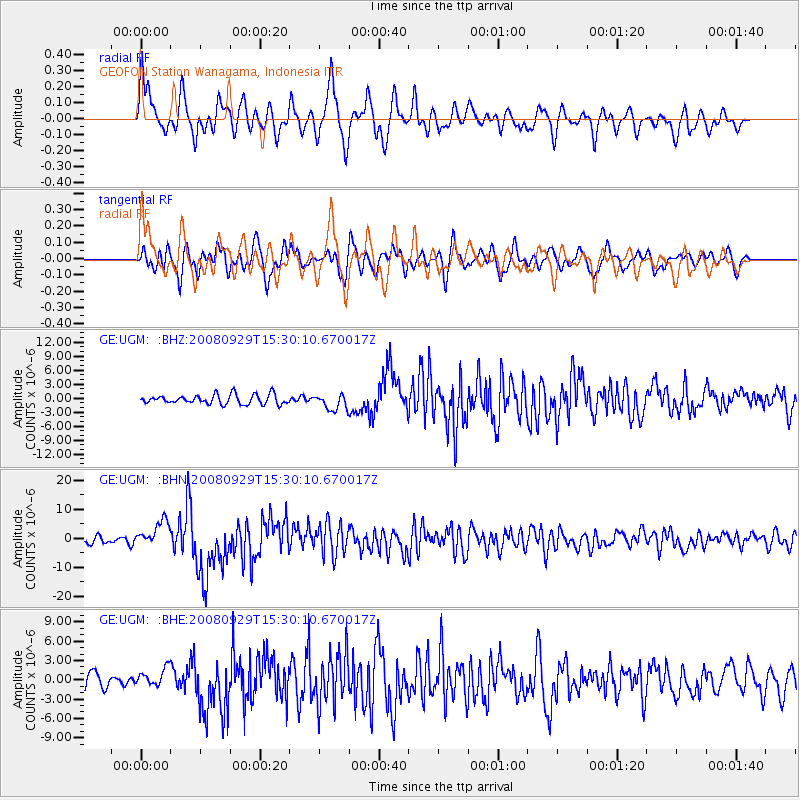
Earthquake location: Kermadec Islands, New Zealand
Earthquake latitude/longitude: -29.8/-177.7
Earthquake time(UTC): 2008/09/29 (273) 15:19:31 GMT
Earthquake Depth: 36 km
Earthquake Magnitude: 6.5 MB, 6.7 MS, 7.0 MW, 7.0 MW
Earthquake Catalog/Contributor: WHDF/NEIC
Network: GE GEOFON
Station: UGM GEOFON Station Wanagama, Indonesia
Lat/Lon: 7.91 S/110.52 E
Elevation: 350 m
Distance: 70.3 deg
Az: 272.064 deg
Baz: 118.687 deg
Ray Param: 0.05499942
Estimated Moho Depth: 16.75 km
Estimated Crust Vp/Vs: 1.79
Assumed Crust Vp: 6.343 km/s
Estimated Crust Vs: 3.554 km/s
Estimated Crust Poisson's Ratio: 0.27
Radial Match: 83.409164 %
Radial Bump: 400
Transverse Match: 68.48415 %
Transverse Bump: 400
SOD ConfigId: 2560
Insert Time: 2010-03-09 05:10:47.217 +0000
GWidth: 2.5
Max Bumps: 400
Tol: 0.001

Signal To Noise

ChannelStoNSTALTA
GE:UGM: :BHN:20080929T15:30:10.670017Z4.0223174.531396E-61.1265636E-6
GE:UGM: :BHE:20080929T15:30:10.670017Z1.4576711.4378746E-69.864191E-7
GE:UGM: :BHZ:20080929T15:30:10.670017Z1.68721881.708147E-61.0124039E-6
Arrivals
Ps2.1 SECOND
PpPs7.1 SECOND
PsPs/PpSs9.2 SECOND