You are here: Home > Network List > GE - GEOFON Stations List
> Station UGM GEOFON Station Wanagama, Indonesia > Earthquake Result Viewer
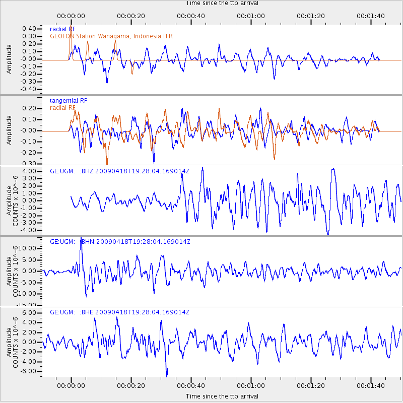
UGM GEOFON Station Wanagama, Indonesia - Earthquake Result Viewer
*The percent match for this event was below the threshold and hence no stack was calculated.
| Earthquake location: |
Kuril Islands |
| Earthquake latitude/longitude: |
46.0/151.4 |
| Earthquake time(UTC): |
2009/04/18 (108) 19:17:58 GMT |
| Earthquake Depth: |
35 km |
| Earthquake Magnitude: |
6.3 MB, 6.3 MS, 6.6 MW, 6.4 MW |
| Earthquake Catalog/Contributor: |
WHDF/NEIC |
|
| Network: |
GE GEOFON |
| Station: |
UGM GEOFON Station Wanagama, Indonesia |
| Lat/Lon: |
7.91 S/110.52 E |
| Elevation: |
350 m |
|
| Distance: |
64.9 deg |
| Az: |
225.732 deg |
| Baz: |
30.249 deg |
| Ray Param: |
$rayparam |
*The percent match for this event was below the threshold and hence was not used in the summary stack. |
|
| Radial Match: |
75.51324 % |
| Radial Bump: |
400 |
| Transverse Match: |
77.503914 % |
| Transverse Bump: |
400 |
| SOD ConfigId: |
2658 |
| Insert Time: |
2010-03-09 05:11:11.909 +0000 |
| GWidth: |
2.5 |
| Max Bumps: |
400 |
| Tol: |
0.001 |
|
Signal To Noise
| Channel | StoN | STA | LTA |
| GE:UGM: :BHN:20090418T19:28:04.169014Z | 7.0358458 | 5.142493E-6 | 7.308991E-7 |
| GE:UGM: :BHE:20090418T19:28:04.169014Z | 1.8409268 | 1.3174564E-6 | 7.1564847E-7 |
| GE:UGM: :BHZ:20090418T19:28:04.169014Z | 0.9750224 | 6.116241E-7 | 6.2729237E-7 |
| Arrivals |
| Ps | |
| PpPs | |
| PsPs/PpSs | |


