You are here: Home > Network List > GE - GEOFON Stations List
> Station UGM GEOFON Station Wanagama, Indonesia > Earthquake Result Viewer
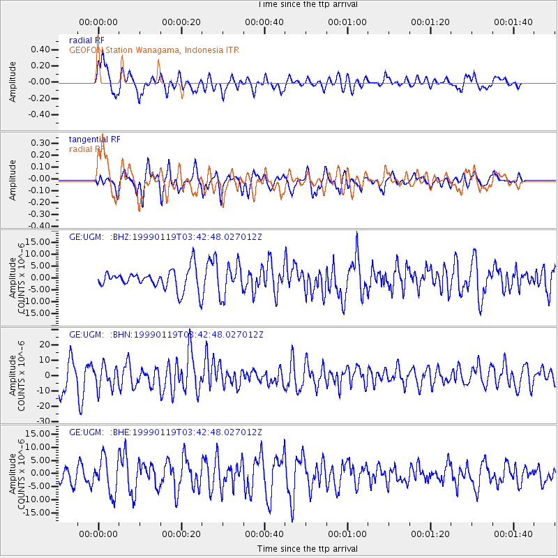
UGM GEOFON Station Wanagama, Indonesia - Earthquake Result Viewer
*The percent match for this event was below the threshold and hence no stack was calculated.
| Earthquake location: |
New Ireland Region, P.N.G. |
| Earthquake latitude/longitude: |
-4.6/153.2 |
| Earthquake time(UTC): |
1999/01/19 (019) 03:35:33 GMT |
| Earthquake Depth: |
114 km |
| Earthquake Magnitude: |
5.8 MB, 6.4 MS, 7.0 MW, 6.5 ME |
| Earthquake Catalog/Contributor: |
WHDF/NEIC |
|
| Network: |
GE GEOFON |
| Station: |
UGM GEOFON Station Wanagama, Indonesia |
| Lat/Lon: |
7.91 S/110.52 E |
| Elevation: |
350 m |
|
| Distance: |
42.6 deg |
| Az: |
263.346 deg |
| Baz: |
88.194 deg |
| Ray Param: |
$rayparam |
*The percent match for this event was below the threshold and hence was not used in the summary stack. |
|
| Radial Match: |
79.84954 % |
| Radial Bump: |
400 |
| Transverse Match: |
68.54952 % |
| Transverse Bump: |
400 |
| SOD ConfigId: |
4480 |
| Insert Time: |
2010-03-09 05:11:22.299 +0000 |
| GWidth: |
2.5 |
| Max Bumps: |
400 |
| Tol: |
0.001 |
|
Signal To Noise
| Channel | StoN | STA | LTA |
| GE:UGM: :BHN:19990119T03:42:48.027012Z | 1.007363 | 7.429931E-6 | 7.3756246E-6 |
| GE:UGM: :BHE:19990119T03:42:48.027012Z | 2.9838214 | 6.947056E-6 | 2.3282412E-6 |
| GE:UGM: :BHZ:19990119T03:42:48.027012Z | 1.5499047 | 6.49749E-6 | 4.1921867E-6 |
| Arrivals |
| Ps | |
| PpPs | |
| PsPs/PpSs | |


