You are here: Home > Network List > GE - GEOFON Stations List
> Station UGM GEOFON Station Wanagama, Indonesia > Earthquake Result Viewer
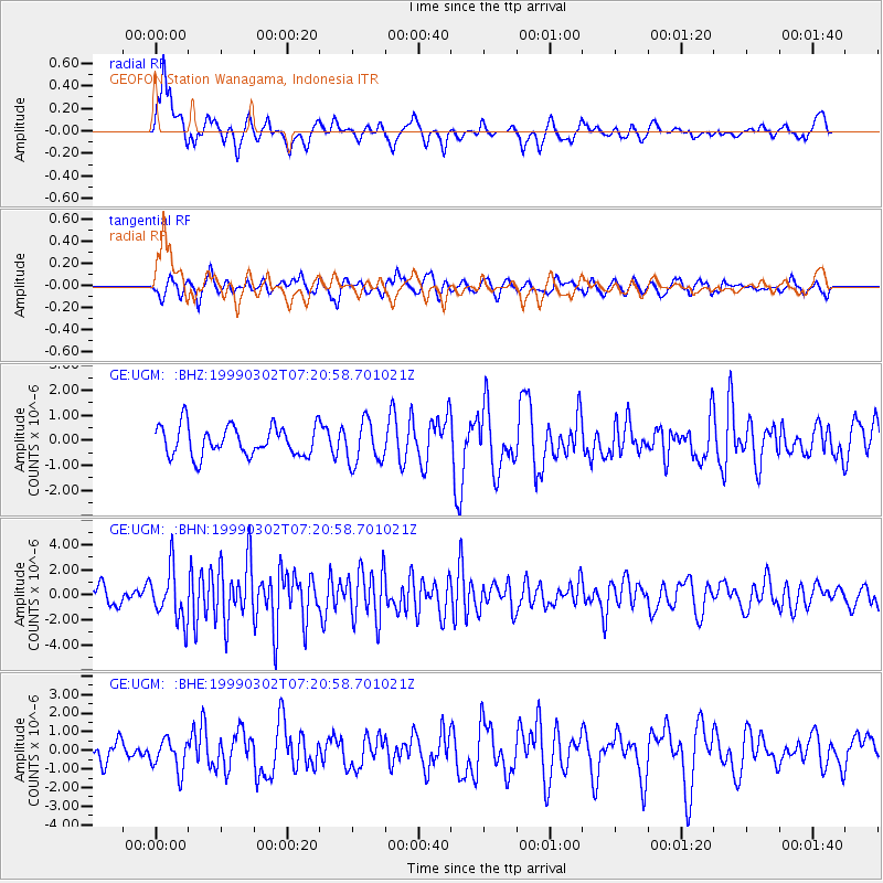
UGM GEOFON Station Wanagama, Indonesia - Earthquake Result Viewer
*The percent match for this event was below the threshold and hence no stack was calculated.
| Earthquake location: |
Near East Coast Of Honshu, Japan |
| Earthquake latitude/longitude: |
35.6/141.8 |
| Earthquake time(UTC): |
1999/03/02 (061) 07:12:20 GMT |
| Earthquake Depth: |
33 km |
| Earthquake Magnitude: |
5.6 MS, 5.4 MB, 6.1 MW, 6.0 MW |
| Earthquake Catalog/Contributor: |
WHDF/NEIC |
|
| Network: |
GE GEOFON |
| Station: |
UGM GEOFON Station Wanagama, Indonesia |
| Lat/Lon: |
7.91 S/110.52 E |
| Elevation: |
350 m |
|
| Distance: |
52.3 deg |
| Az: |
220.455 deg |
| Baz: |
32.266 deg |
| Ray Param: |
$rayparam |
*The percent match for this event was below the threshold and hence was not used in the summary stack. |
|
| Radial Match: |
72.28722 % |
| Radial Bump: |
400 |
| Transverse Match: |
61.34724 % |
| Transverse Bump: |
400 |
| SOD ConfigId: |
4480 |
| Insert Time: |
2010-03-09 05:11:25.149 +0000 |
| GWidth: |
2.5 |
| Max Bumps: |
400 |
| Tol: |
0.001 |
|
Signal To Noise
| Channel | StoN | STA | LTA |
| GE:UGM: :BHN:19990302T07:20:58.701021Z | 2.9469018 | 2.0843277E-6 | 7.072946E-7 |
| GE:UGM: :BHE:19990302T07:20:58.701021Z | 1.2882444 | 8.444652E-7 | 6.555163E-7 |
| GE:UGM: :BHZ:19990302T07:20:58.701021Z | 1.4440717 | 8.558642E-7 | 5.926743E-7 |
| Arrivals |
| Ps | |
| PpPs | |
| PsPs/PpSs | |


