You are here: Home > Network List > GE - GEOFON Stations List
> Station UGM GEOFON Station Wanagama, Indonesia > Earthquake Result Viewer
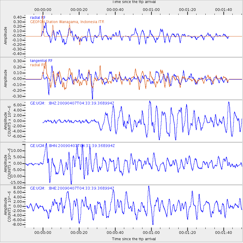
UGM GEOFON Station Wanagama, Indonesia - Earthquake Result Viewer
*The percent match for this event was below the threshold and hence no stack was calculated.
| Earthquake location: |
Kuril Islands |
| Earthquake latitude/longitude: |
46.0/151.5 |
| Earthquake time(UTC): |
2009/04/07 (097) 04:23:33 GMT |
| Earthquake Depth: |
31 km |
| Earthquake Magnitude: |
6.5 MB, 6.8 MS, 6.9 MW, 6.9 MW |
| Earthquake Catalog/Contributor: |
WHDF/NEIC |
|
| Network: |
GE GEOFON |
| Station: |
UGM GEOFON Station Wanagama, Indonesia |
| Lat/Lon: |
7.91 S/110.52 E |
| Elevation: |
350 m |
|
| Distance: |
65.0 deg |
| Az: |
225.835 deg |
| Baz: |
30.287 deg |
| Ray Param: |
$rayparam |
*The percent match for this event was below the threshold and hence was not used in the summary stack. |
|
| Radial Match: |
85.172745 % |
| Radial Bump: |
400 |
| Transverse Match: |
88.10357 % |
| Transverse Bump: |
400 |
| SOD ConfigId: |
2658 |
| Insert Time: |
2010-03-09 05:11:52.430 +0000 |
| GWidth: |
2.5 |
| Max Bumps: |
400 |
| Tol: |
0.001 |
|
Signal To Noise
| Channel | StoN | STA | LTA |
| GE:UGM: :BHN:20090407T04:33:39.368994Z | 13.486649 | 8.3505465E-6 | 6.191714E-7 |
| GE:UGM: :BHE:20090407T04:33:39.368994Z | 4.062775 | 2.1319663E-6 | 5.2475616E-7 |
| GE:UGM: :BHZ:20090407T04:33:39.368994Z | 5.6168737 | 1.8632019E-6 | 3.317151E-7 |
| Arrivals |
| Ps | |
| PpPs | |
| PsPs/PpSs | |


