You are here: Home > Network List > GE - GEOFON Stations List
> Station UGM GEOFON Station Wanagama, Indonesia > Earthquake Result Viewer
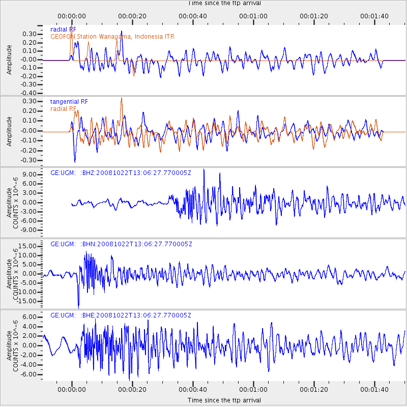
UGM GEOFON Station Wanagama, Indonesia - Earthquake Result Viewer
*The percent match for this event was below the threshold and hence no stack was calculated.
| Earthquake location: |
Tonga Islands |
| Earthquake latitude/longitude: |
-18.4/-175.4 |
| Earthquake time(UTC): |
2008/10/22 (296) 12:55:57 GMT |
| Earthquake Depth: |
233 km |
| Earthquake Magnitude: |
5.9 MB, 6.4 MW, 6.3 MW |
| Earthquake Catalog/Contributor: |
WHDF/NEIC |
|
| Network: |
GE GEOFON |
| Station: |
UGM GEOFON Station Wanagama, Indonesia |
| Lat/Lon: |
7.91 S/110.52 E |
| Elevation: |
350 m |
|
| Distance: |
72.5 deg |
| Az: |
267.31 deg |
| Baz: |
106.788 deg |
| Ray Param: |
$rayparam |
*The percent match for this event was below the threshold and hence was not used in the summary stack. |
|
| Radial Match: |
55.998714 % |
| Radial Bump: |
400 |
| Transverse Match: |
74.42793 % |
| Transverse Bump: |
400 |
| SOD ConfigId: |
2556 |
| Insert Time: |
2010-03-09 05:11:55.360 +0000 |
| GWidth: |
2.5 |
| Max Bumps: |
400 |
| Tol: |
0.001 |
|
Signal To Noise
| Channel | StoN | STA | LTA |
| GE:UGM: :BHN:20081022T13:06:27.770005Z | 6.5765014 | 5.6294034E-6 | 8.5598754E-7 |
| GE:UGM: :BHE:20081022T13:06:27.770005Z | 1.6518817 | 1.7812511E-6 | 1.0783164E-6 |
| GE:UGM: :BHZ:20081022T13:06:27.770005Z | 1.5542121 | 1.1611221E-6 | 7.470809E-7 |
| Arrivals |
| Ps | |
| PpPs | |
| PsPs/PpSs | |


