You are here: Home > Network List > GE - GEOFON Stations List
> Station UGM GEOFON Station Wanagama, Indonesia > Earthquake Result Viewer
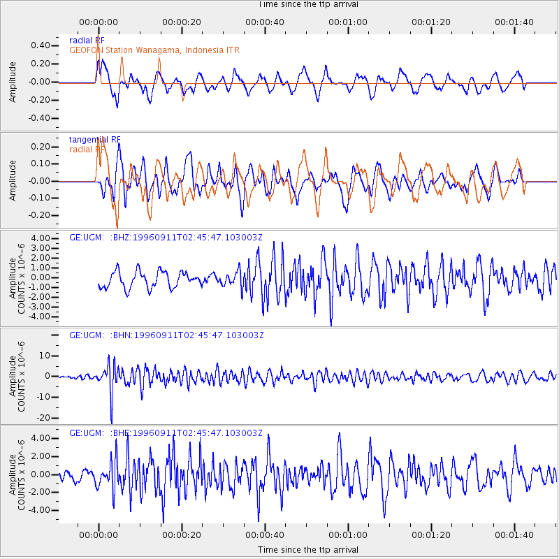
UGM GEOFON Station Wanagama, Indonesia - Earthquake Result Viewer
*The percent match for this event was below the threshold and hence no stack was calculated.
| Earthquake location: |
Near East Coast Of Honshu, Japan |
| Earthquake latitude/longitude: |
35.5/140.9 |
| Earthquake time(UTC): |
1996/09/11 (255) 02:37:14 GMT |
| Earthquake Depth: |
55 km |
| Earthquake Magnitude: |
6.1 MB, 5.7 MS, 6.2 UNKNOWN, 6.1 MW |
| Earthquake Catalog/Contributor: |
WHDF/NEIC |
|
| Network: |
GE GEOFON |
| Station: |
UGM GEOFON Station Wanagama, Indonesia |
| Lat/Lon: |
7.91 S/110.52 E |
| Elevation: |
350 m |
|
| Distance: |
51.9 deg |
| Az: |
219.622 deg |
| Baz: |
31.671 deg |
| Ray Param: |
$rayparam |
*The percent match for this event was below the threshold and hence was not used in the summary stack. |
|
| Radial Match: |
65.59847 % |
| Radial Bump: |
400 |
| Transverse Match: |
66.579575 % |
| Transverse Bump: |
400 |
| SOD ConfigId: |
4480 |
| Insert Time: |
2010-03-09 05:11:56.812 +0000 |
| GWidth: |
2.5 |
| Max Bumps: |
400 |
| Tol: |
0.001 |
|
Signal To Noise
| Channel | StoN | STA | LTA |
| GE:UGM: :BHN:19960911T02:45:47.103003Z | 11.035823 | 6.9287466E-6 | 6.278414E-7 |
| GE:UGM: :BHE:19960911T02:45:47.103003Z | 1.7908514 | 1.5513932E-6 | 8.6628813E-7 |
| GE:UGM: :BHZ:19960911T02:45:47.103003Z | 0.9576201 | 7.8643535E-7 | 8.212394E-7 |
| Arrivals |
| Ps | |
| PpPs | |
| PsPs/PpSs | |


