You are here: Home > Network List > GE - GEOFON Stations List
> Station UGM GEOFON Station Wanagama, Indonesia > Earthquake Result Viewer
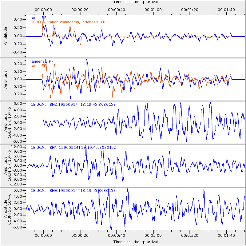
UGM GEOFON Station Wanagama, Indonesia - Earthquake Result Viewer
*The percent match for this event was below the threshold and hence no stack was calculated.
| Earthquake location: |
Santa Cruz Islands |
| Earthquake latitude/longitude: |
-10.9/166.0 |
| Earthquake time(UTC): |
1996/09/14 (258) 13:10:53 GMT |
| Earthquake Depth: |
73 km |
| Earthquake Magnitude: |
6.0 MB, 6.0 MS, 6.4 UNKNOWN, 6.4 MW |
| Earthquake Catalog/Contributor: |
WHDF/NEIC |
|
| Network: |
GE GEOFON |
| Station: |
UGM GEOFON Station Wanagama, Indonesia |
| Lat/Lon: |
7.91 S/110.52 E |
| Elevation: |
350 m |
|
| Distance: |
54.7 deg |
| Az: |
267.962 deg |
| Baz: |
97.713 deg |
| Ray Param: |
$rayparam |
*The percent match for this event was below the threshold and hence was not used in the summary stack. |
|
| Radial Match: |
72.32628 % |
| Radial Bump: |
400 |
| Transverse Match: |
70.29573 % |
| Transverse Bump: |
400 |
| SOD ConfigId: |
4480 |
| Insert Time: |
2010-03-09 05:11:57.783 +0000 |
| GWidth: |
2.5 |
| Max Bumps: |
400 |
| Tol: |
0.001 |
|
Signal To Noise
| Channel | StoN | STA | LTA |
| GE:UGM: :BHN:19960914T13:19:45.303015Z | 2.2414832 | 2.4531803E-6 | 1.0944451E-6 |
| GE:UGM: :BHE:19960914T13:19:45.303015Z | 1.1852232 | 1.0109151E-6 | 8.5293226E-7 |
| GE:UGM: :BHZ:19960914T13:19:45.303015Z | 1.2626623 | 1.0769558E-6 | 8.529247E-7 |
| Arrivals |
| Ps | |
| PpPs | |
| PsPs/PpSs | |


