You are here: Home > Network List > GE - GEOFON Stations List
> Station UGM GEOFON Station Wanagama, Indonesia > Earthquake Result Viewer
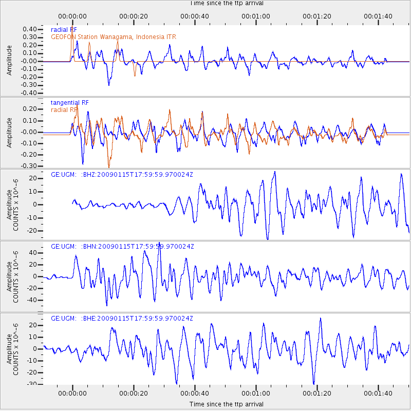
UGM GEOFON Station Wanagama, Indonesia - Earthquake Result Viewer
*The percent match for this event was below the threshold and hence no stack was calculated.
| Earthquake location: |
East Of Kuril Islands |
| Earthquake latitude/longitude: |
46.9/155.2 |
| Earthquake time(UTC): |
2009/01/15 (015) 17:49:39 GMT |
| Earthquake Depth: |
36 km |
| Earthquake Magnitude: |
6.9 MB, 7.5 MS, 7.4 MW, 7.4 MW |
| Earthquake Catalog/Contributor: |
WHDF/NEIC |
|
| Network: |
GE GEOFON |
| Station: |
UGM GEOFON Station Wanagama, Indonesia |
| Lat/Lon: |
7.91 S/110.52 E |
| Elevation: |
350 m |
|
| Distance: |
67.4 deg |
| Az: |
228.923 deg |
| Baz: |
31.482 deg |
| Ray Param: |
$rayparam |
*The percent match for this event was below the threshold and hence was not used in the summary stack. |
|
| Radial Match: |
80.38125 % |
| Radial Bump: |
400 |
| Transverse Match: |
78.33704 % |
| Transverse Bump: |
400 |
| SOD ConfigId: |
2834 |
| Insert Time: |
2010-03-09 05:11:58.432 +0000 |
| GWidth: |
2.5 |
| Max Bumps: |
400 |
| Tol: |
0.001 |
|
Signal To Noise
| Channel | StoN | STA | LTA |
| GE:UGM: :BHN:20090115T17:59:59.970024Z | 9.149628 | 1.7401899E-5 | 1.9019242E-6 |
| GE:UGM: :BHE:20090115T17:59:59.970024Z | 2.2007022 | 4.6492823E-6 | 2.112636E-6 |
| GE:UGM: :BHZ:20090115T17:59:59.970024Z | 2.8406222 | 4.3167297E-6 | 1.5196423E-6 |
| Arrivals |
| Ps | |
| PpPs | |
| PsPs/PpSs | |


