You are here: Home > Network List > GE - GEOFON Stations List
> Station UGM GEOFON Station Wanagama, Indonesia > Earthquake Result Viewer
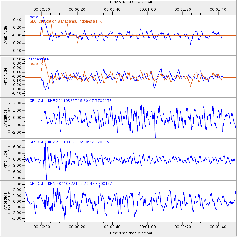
UGM GEOFON Station Wanagama, Indonesia - Earthquake Result Viewer
*The percent match for this event was below the threshold and hence no stack was calculated.
| Earthquake location: |
Near East Coast Of Honshu, Japan |
| Earthquake latitude/longitude: |
35.7/141.6 |
| Earthquake time(UTC): |
2011/03/22 (081) 16:12:09 GMT |
| Earthquake Depth: |
31 km |
| Earthquake Magnitude: |
5.6 MB, 5.2 MS, 5.3 MW |
| Earthquake Catalog/Contributor: |
WHDF/NEIC |
|
| Network: |
GE GEOFON |
| Station: |
UGM GEOFON Station Wanagama, Indonesia |
| Lat/Lon: |
7.91 S/110.52 E |
| Elevation: |
350 m |
|
| Distance: |
52.3 deg |
| Az: |
220.29 deg |
| Baz: |
32.103 deg |
| Ray Param: |
$rayparam |
*The percent match for this event was below the threshold and hence was not used in the summary stack. |
|
| Radial Match: |
63.426163 % |
| Radial Bump: |
400 |
| Transverse Match: |
60.72406 % |
| Transverse Bump: |
400 |
| SOD ConfigId: |
356183 |
| Insert Time: |
2011-08-18 20:08:17.926 +0000 |
| GWidth: |
2.5 |
| Max Bumps: |
400 |
| Tol: |
0.001 |
|
Signal To Noise
| Channel | StoN | STA | LTA |
| GE:UGM: :BHZ:20110322T16:20:47.370015Z | 4.208423 | 3.8993703E-6 | 9.265633E-7 |
| GE:UGM: :BHN:20110322T16:20:47.370015Z | 1.0924923 | 8.624637E-7 | 7.8944595E-7 |
| GE:UGM: :BHE:20110322T16:20:47.370015Z | 1.324004 | 8.372658E-7 | 6.3237405E-7 |
| Arrivals |
| Ps | |
| PpPs | |
| PsPs/PpSs | |


