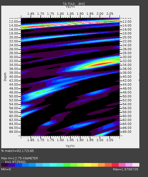
TOLK Toolik Lake Research Station, AK, USA - Earthquake Result Viewer

Earthquake location: Near East Coast Of Honshu, Japan
Earthquake latitude/longitude: 38.9/141.8
Earthquake time(UTC): 2012/06/17 (169) 20:32:20 GMT
Earthquake Depth: 36 km
Earthquake Magnitude: 6.0 MB, 5.9 MS, 6.3 MW, 6.4 MW
Earthquake Catalog/Contributor: WHDF/NEIC
Network: TA USArray Transportable Network (new EarthScope stations)
Station: TOLK Toolik Lake Research Station, AK, USA
Lat/Lon: 68.64 N/149.57 W
Elevation: 760 m
Distance: 46.6 deg
Az: 27.972 deg
Baz: 267.187 deg
Ray Param: 0.07043724
Estimated Moho Depth: 12.75 km
Estimated Crust Vp/Vs: 1.87
Assumed Crust Vp: 6.316 km/s
Estimated Crust Vs: 3.373 km/s
Estimated Crust Poisson's Ratio: 0.30
Radial Match: 92.172165 %
Radial Bump: 400
Transverse Match: 83.53423 %
Transverse Bump: 400
SOD ConfigId: 460165
Insert Time: 2013-02-11 21:27:28.614 +0000
GWidth: 2.5
Max Bumps: 400
Tol: 0.001

Signal To Noise

ChannelStoNSTALTA
TA:TOLK: :BHZ:20120617T20:40:15.000004Z18.408721.6045444E-68.716219E-8
TA:TOLK: :BHN:20120617T20:40:15.000004Z3.12089251.9065472E-76.108981E-8
TA:TOLK: :BHE:20120617T20:40:15.000004Z11.588896.763787E-75.8364403E-8
Arrivals
Ps1.9 SECOND
PpPs5.5 SECOND
PsPs/PpSs7.3 SECOND