You are here: Home > Network List > GE - GEOFON Stations List
> Station UGM GEOFON Station Wanagama, Indonesia > Earthquake Result Viewer
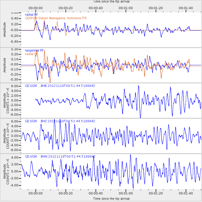
UGM GEOFON Station Wanagama, Indonesia - Earthquake Result Viewer
*The percent match for this event was below the threshold and hence no stack was calculated.
| Earthquake location: |
New Britain Region, P.N.G. |
| Earthquake latitude/longitude: |
-5.7/151.6 |
| Earthquake time(UTC): |
2012/11/19 (324) 09:44:34 GMT |
| Earthquake Depth: |
13 km |
| Earthquake Magnitude: |
5.9 MB, 5.9 MS, 6.0 MW, 5.9 MW |
| Earthquake Catalog/Contributor: |
WHDF/NEIC |
|
| Network: |
GE GEOFON |
| Station: |
UGM GEOFON Station Wanagama, Indonesia |
| Lat/Lon: |
7.91 S/110.52 E |
| Elevation: |
350 m |
|
| Distance: |
40.8 deg |
| Az: |
264.528 deg |
| Baz: |
89.583 deg |
| Ray Param: |
$rayparam |
*The percent match for this event was below the threshold and hence was not used in the summary stack. |
|
| Radial Match: |
67.12015 % |
| Radial Bump: |
400 |
| Transverse Match: |
59.528435 % |
| Transverse Bump: |
400 |
| SOD ConfigId: |
486959 |
| Insert Time: |
2013-03-21 19:22:17.095 +0000 |
| GWidth: |
2.5 |
| Max Bumps: |
400 |
| Tol: |
0.001 |
|
Signal To Noise
| Channel | StoN | STA | LTA |
| GE:UGM: :BHZ:20121119T09:51:44.519994Z | 3.0907037 | 2.8575369E-6 | 9.2455866E-7 |
| GE:UGM: :BHN:20121119T09:51:44.519994Z | 0.8661931 | 8.4203543E-7 | 9.721106E-7 |
| GE:UGM: :BHE:20121119T09:51:44.519994Z | 2.528763 | 1.7359425E-6 | 6.864789E-7 |
| Arrivals |
| Ps | |
| PpPs | |
| PsPs/PpSs | |


