UGM GEOFON Station Wanagama, Indonesia - Earthquake Result Viewer
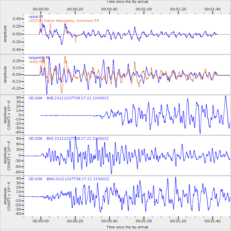
Earthquake location: Off East Coast Of Honshu, Japan
Earthquake latitude/longitude: 37.9/143.9
Earthquake time(UTC): 2012/12/07 (342) 08:18:23 GMT
Earthquake Depth: 31 km
Earthquake Magnitude: 7.2 MB, 7.3 MS, 7.3 MW, 7.3 MW
Earthquake Catalog/Contributor: WHDF/NEIC
Network: GE GEOFON
Station: UGM GEOFON Station Wanagama, Indonesia
Lat/Lon: 7.91 S/110.52 E
Elevation: 350 m
Distance: 55.2 deg
Az: 221.637 deg
Baz: 32.05 deg
Ray Param: 0.064883955
Estimated Moho Depth: 14.25 km
Estimated Crust Vp/Vs: 1.60
Assumed Crust Vp: 6.343 km/s
Estimated Crust Vs: 3.965 km/s
Estimated Crust Poisson's Ratio: 0.18
Radial Match: 85.95613 %
Radial Bump: 400
Transverse Match: 87.22145 %
Transverse Bump: 400
SOD ConfigId: 488671
Insert Time: 2013-03-29 04:15:55.642 +0000
GWidth: 2.5
Max Bumps: 400
Tol: 0.001

Signal To Noise

ChannelStoNSTALTA
GE:UGM: :BHZ:20121207T08:27:22.320002Z30.6725731.1116374E-53.6242065E-7
GE:UGM: :BHN:20121207T08:27:22.320002Z7.8502162.1728201E-62.7678476E-7
GE:UGM: :BHE:20121207T08:27:22.320002Z3.07433728.3173006E-72.7053966E-7
Arrivals
Ps1.4 SECOND
PpPs5.5 SECOND
PsPs/PpSs6.9 SECOND