You are here: Home > Network List > GE - GEOFON Stations List
> Station UGM GEOFON Station Wanagama, Indonesia > Earthquake Result Viewer
UGM GEOFON Station Wanagama, Indonesia - Earthquake Result Viewer
| Earthquake location: |
Santa Cruz Islands |
| Earthquake latitude/longitude: |
-10.9/165.2 |
| Earthquake time(UTC): |
2013/02/06 (037) 00:07:22 GMT |
| Earthquake Depth: |
11 km |
| Earthquake Magnitude: |
5.6 MB, 6.1 MS, 6.0 MW, 6.0 MW |
| Earthquake Catalog/Contributor: |
WHDF/NEIC |
|
| Network: |
GE GEOFON |
| Station: |
UGM GEOFON Station Wanagama, Indonesia |
| Lat/Lon: |
7.91 S/110.52 E |
| Elevation: |
350 m |
|
| Distance: |
54.0 deg |
| Az: |
268.073 deg |
| Baz: |
97.665 deg |
| Ray Param: |
0.06571028 |
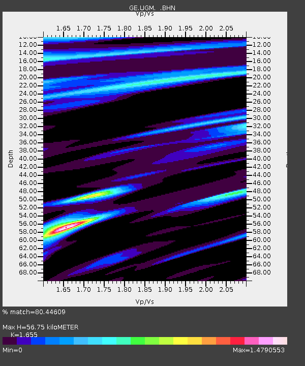
| Estimated Moho Depth: |
56.75 km |
| Estimated Crust Vp/Vs: |
1.65 |
| Assumed Crust Vp: |
6.343 km/s |
| Estimated Crust Vs: |
3.833 km/s |
| Estimated Crust Poisson's Ratio: |
0.21 |
|
| Radial Match: |
80.44609 % |
| Radial Bump: |
360 |
| Transverse Match: |
69.04295 % |
| Transverse Bump: |
400 |
| SOD ConfigId: |
494114 |
| Insert Time: |
2013-05-01 04:14:43.691 +0000 |
| GWidth: |
2.5 |
| Max Bumps: |
400 |
| Tol: |
0.001 |
|
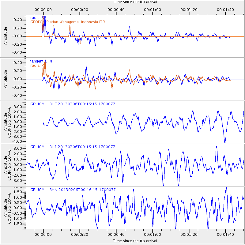
Signal To Noise
| Channel | StoN | STA | LTA |
| GE:UGM: :BHZ:20130206T00:16:15.170007Z | 2.1904442 | 9.128553E-7 | 4.1674437E-7 |
| GE:UGM: :BHN:20130206T00:16:15.170007Z | 0.57805324 | 2.6997563E-7 | 4.6704287E-7 |
| GE:UGM: :BHE:20130206T00:16:15.170007Z | 0.48202074 | 2.5245888E-7 | 5.2375105E-7 |
| Arrivals |
| Ps | 6.2 SECOND |
| PpPs | 22 SECOND |
| PsPs/PpSs | 29 SECOND |


