You are here: Home > Network List > GE - GEOFON Stations List
> Station UGM GEOFON Station Wanagama, Indonesia > Earthquake Result Viewer
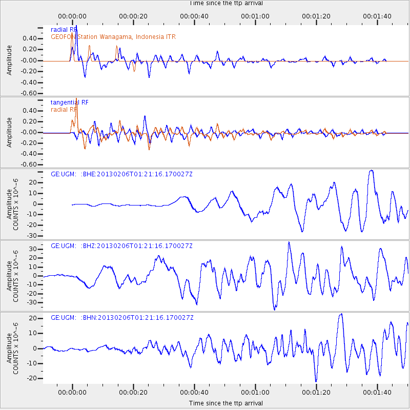
UGM GEOFON Station Wanagama, Indonesia - Earthquake Result Viewer
*The percent match for this event was below the threshold and hence no stack was calculated.
| Earthquake location: |
Santa Cruz Islands |
| Earthquake latitude/longitude: |
-10.8/165.1 |
| Earthquake time(UTC): |
2013/02/06 (037) 01:12:25 GMT |
| Earthquake Depth: |
24 km |
| Earthquake Magnitude: |
6.4 MB, 7.4 MS, 8.0 MW, 7.9 MW |
| Earthquake Catalog/Contributor: |
WHDF/NEIC |
|
| Network: |
GE GEOFON |
| Station: |
UGM GEOFON Station Wanagama, Indonesia |
| Lat/Lon: |
7.91 S/110.52 E |
| Elevation: |
350 m |
|
| Distance: |
53.9 deg |
| Az: |
268.048 deg |
| Baz: |
97.579 deg |
| Ray Param: |
$rayparam |
*The percent match for this event was below the threshold and hence was not used in the summary stack. |
|
| Radial Match: |
95.258484 % |
| Radial Bump: |
315 |
| Transverse Match: |
83.00546 % |
| Transverse Bump: |
400 |
| SOD ConfigId: |
494114 |
| Insert Time: |
2013-05-01 04:28:55.855 +0000 |
| GWidth: |
2.5 |
| Max Bumps: |
400 |
| Tol: |
0.001 |
|
Signal To Noise
| Channel | StoN | STA | LTA |
| GE:UGM: :BHZ:20130206T01:21:16.170027Z | 8.566852 | 4.969627E-6 | 5.8009954E-7 |
| GE:UGM: :BHN:20130206T01:21:16.170027Z | 0.5928189 | 3.7059567E-7 | 6.2514147E-7 |
| GE:UGM: :BHE:20130206T01:21:16.170027Z | 3.3176014 | 2.198407E-6 | 6.626495E-7 |
| Arrivals |
| Ps | |
| PpPs | |
| PsPs/PpSs | |


