Q61A Milford, DE, USA - Earthquake Result Viewer
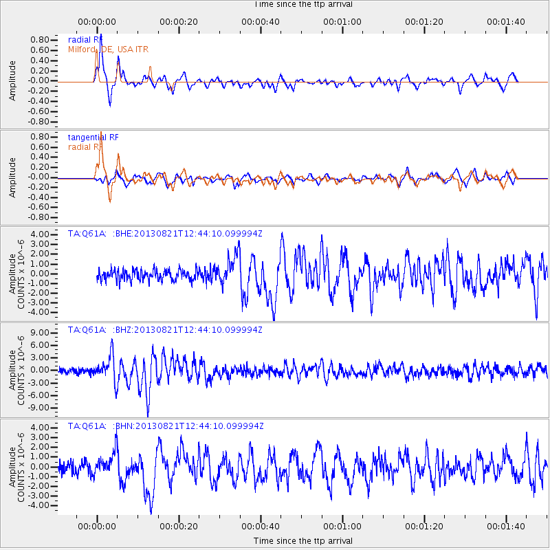
Earthquake location: Near Coast Of Guerrero, Mexico
Earthquake latitude/longitude: 16.9/-99.5
Earthquake time(UTC): 2013/08/21 (233) 12:38:29 GMT
Earthquake Depth: 21 km
Earthquake Magnitude: 6.2 MWW, 6.2 MWW, 6.2 MWB, 6.2 MWC
Earthquake Catalog/Contributor: NEIC PDE/NEIC COMCAT
Network: TA USArray Transportable Network (new EarthScope stations)
Station: Q61A Milford, DE, USA
Lat/Lon: 38.88 N/75.33 W
Elevation: 5.0 m
Distance: 30.4 deg
Az: 39.115 deg
Baz: 230.706 deg
Ray Param: 0.07931834
Estimated Moho Depth: 29.0 km
Estimated Crust Vp/Vs: 2.10
Assumed Crust Vp: 6.287 km/s
Estimated Crust Vs: 3.001 km/s
Estimated Crust Poisson's Ratio: 0.35
Radial Match: 86.091736 %
Radial Bump: 400
Transverse Match: 82.5448 %
Transverse Bump: 400
SOD ConfigId: 626651
Insert Time: 2014-04-18 02:12:36.379 +0000
GWidth: 2.5
Max Bumps: 400
Tol: 0.001

Signal To Noise

ChannelStoNSTALTA
TA:Q61A: :BHZ:20130821T12:44:10.099994Z5.8102263.1072911E-65.347969E-7
TA:Q61A: :BHN:20130821T12:44:10.099994Z2.4923251.2217773E-64.902159E-7
TA:Q61A: :BHE:20130821T12:44:10.099994Z2.97301051.5068441E-65.0684116E-7
Arrivals
Ps5.4 SECOND
PpPs13 SECOND
PsPs/PpSs19 SECOND