You are here: Home > Network List > TA - USArray Transportable Network (new EarthScope stations) Stations List
> Station Q61A Milford, DE, USA > Earthquake Result Viewer
Q61A Milford, DE, USA - Earthquake Result Viewer
| Earthquake location: |
Near Coast Of Peru |
| Earthquake latitude/longitude: |
-15.8/-74.5 |
| Earthquake time(UTC): |
2013/09/25 (268) 16:42:43 GMT |
| Earthquake Depth: |
40 km |
| Earthquake Magnitude: |
7.1 MWW, 6.8 MI, 7.0 MWB, 7.0 MWC, 7.1 MWW, 7.1 MWC |
| Earthquake Catalog/Contributor: |
NEIC PDE/NEIC COMCAT |
|
| Network: |
TA USArray Transportable Network (new EarthScope stations) |
| Station: |
Q61A Milford, DE, USA |
| Lat/Lon: |
38.88 N/75.33 W |
| Elevation: |
5.0 m |
|
| Distance: |
54.4 deg |
| Az: |
359.219 deg |
| Baz: |
179.036 deg |
| Ray Param: |
0.06536917 |
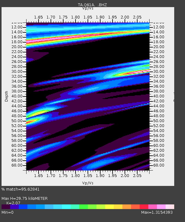
| Estimated Moho Depth: |
29.75 km |
| Estimated Crust Vp/Vs: |
2.07 |
| Assumed Crust Vp: |
6.287 km/s |
| Estimated Crust Vs: |
3.037 km/s |
| Estimated Crust Poisson's Ratio: |
0.35 |
|
| Radial Match: |
95.62841 % |
| Radial Bump: |
340 |
| Transverse Match: |
89.47794 % |
| Transverse Bump: |
355 |
| SOD ConfigId: |
626651 |
| Insert Time: |
2014-04-18 20:45:47.858 +0000 |
| GWidth: |
2.5 |
| Max Bumps: |
400 |
| Tol: |
0.001 |
|
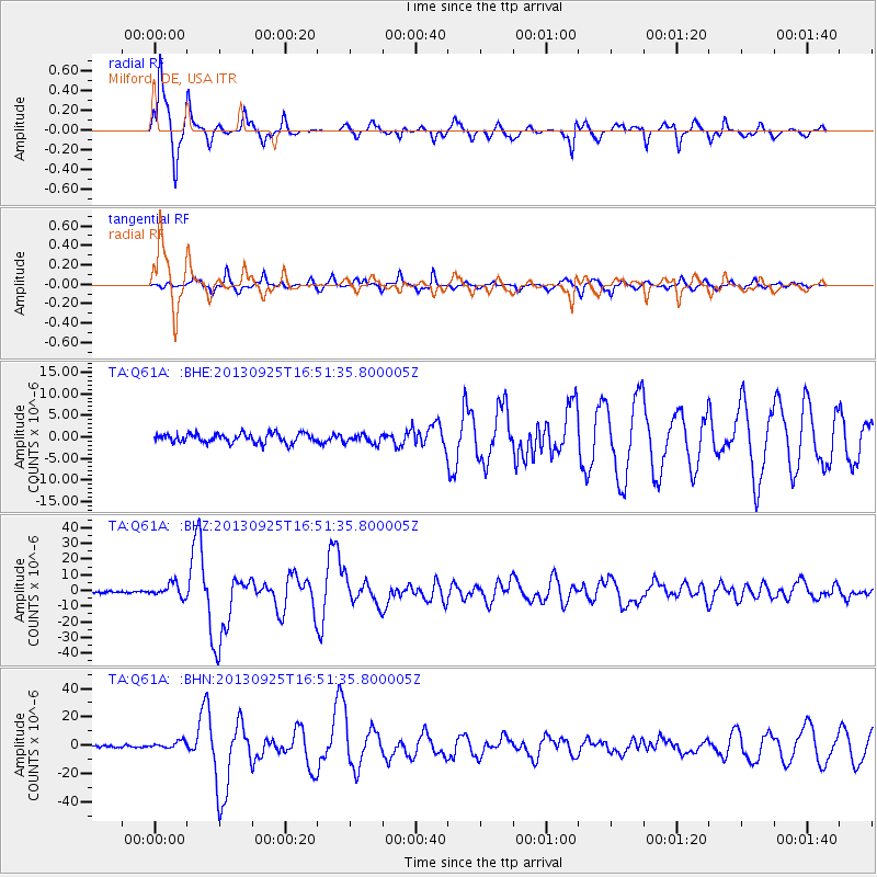
Signal To Noise
| Channel | StoN | STA | LTA |
| TA:Q61A: :BHZ:20130925T16:51:35.800005Z | 5.763279 | 4.1704075E-6 | 7.2361723E-7 |
| TA:Q61A: :BHN:20130925T16:51:35.800005Z | 4.1253076 | 2.5658862E-6 | 6.219867E-7 |
| TA:Q61A: :BHE:20130925T16:51:35.800005Z | 0.9778969 | 1.0598828E-6 | 1.083839E-6 |
| Arrivals |
| Ps | 5.3 SECOND |
| PpPs | 14 SECOND |
| PsPs/PpSs | 19 SECOND |


