You are here: Home > Network List > TA - USArray Transportable Network (new EarthScope stations) Stations List
> Station Q61A Milford, DE, USA > Earthquake Result Viewer
Q61A Milford, DE, USA - Earthquake Result Viewer
| Earthquake location: |
Near Coast Of Northern Chile |
| Earthquake latitude/longitude: |
-20.6/-70.7 |
| Earthquake time(UTC): |
2014/04/04 (094) 01:37:51 GMT |
| Earthquake Depth: |
20 km |
| Earthquake Magnitude: |
6.1 MWP, 6.1 MWB, 6.1 MWW, 6.3 MWC |
| Earthquake Catalog/Contributor: |
NEIC PDE/NEIC COMCAT |
|
| Network: |
TA USArray Transportable Network (new EarthScope stations) |
| Station: |
Q61A Milford, DE, USA |
| Lat/Lon: |
38.88 N/75.33 W |
| Elevation: |
5.0 m |
|
| Distance: |
59.3 deg |
| Az: |
355.839 deg |
| Baz: |
175.005 deg |
| Ray Param: |
0.062228214 |
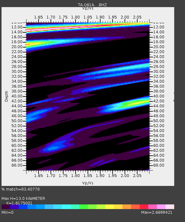
| Estimated Moho Depth: |
13.0 km |
| Estimated Crust Vp/Vs: |
1.62 |
| Assumed Crust Vp: |
6.287 km/s |
| Estimated Crust Vs: |
3.887 km/s |
| Estimated Crust Poisson's Ratio: |
0.19 |
|
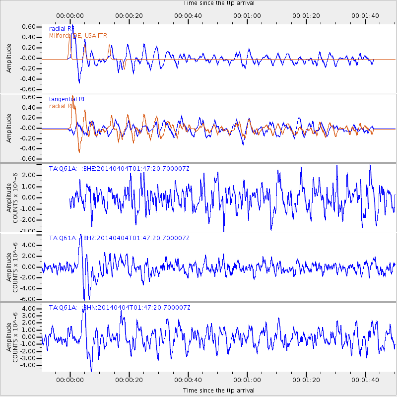
| Radial Match: |
83.40778 % |
| Radial Bump: |
400 |
| Transverse Match: |
60.22871 % |
| Transverse Bump: |
400 |
| SOD ConfigId: |
626651 |
| Insert Time: |
2014-04-22 10:02:01.873 +0000 |
| GWidth: |
2.5 |
| Max Bumps: |
400 |
| Tol: |
0.001 |
|
Signal To Noise
| Channel | StoN | STA | LTA |
| TA:Q61A: :BHZ:20140404T01:47:20.700007Z | 5.073205 | 2.8297322E-6 | 5.5777997E-7 |
| TA:Q61A: :BHN:20140404T01:47:20.700007Z | 2.2208912 | 1.6382554E-6 | 7.3765676E-7 |
| TA:Q61A: :BHE:20140404T01:47:20.700007Z | 0.69376206 | 6.0900913E-7 | 8.778357E-7 |
| Arrivals |
| Ps | 1.3 SECOND |
| PpPs | 5.1 SECOND |
| PsPs/PpSs | 6.5 SECOND |


