You are here: Home > Network List > TX - Texas Seismological Network Stations List
> Station HNVL Huntsville, TX > Earthquake Result Viewer
HNVL Huntsville, TX - Earthquake Result Viewer
| Earthquake location: |
Komandorskiye Ostrova Region |
| Earthquake latitude/longitude: |
54.6/168.6 |
| Earthquake time(UTC): |
2017/07/17 (198) 11:05:08 GMT |
| Earthquake Depth: |
7.9 km |
| Earthquake Magnitude: |
6.2 Mww |
| Earthquake Catalog/Contributor: |
NEIC PDE/us |
|
| Network: |
TX Texas Seismological Network |
| Station: |
HNVL Huntsville, TX |
| Lat/Lon: |
30.76 N/95.47 W |
| Elevation: |
87 m |
|
| Distance: |
68.8 deg |
| Az: |
66.744 deg |
| Baz: |
321.59 deg |
| Ray Param: |
0.05610067 |
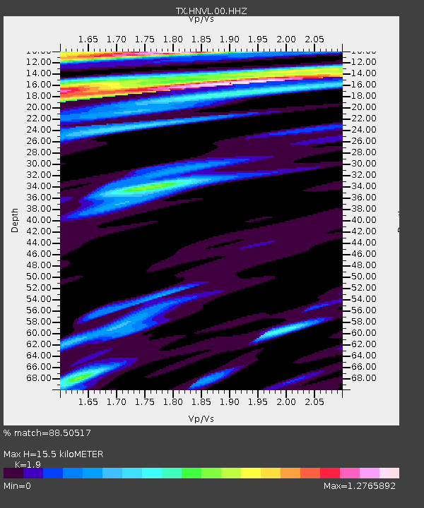
| Estimated Moho Depth: |
15.5 km |
| Estimated Crust Vp/Vs: |
1.90 |
| Assumed Crust Vp: |
5.738 km/s |
| Estimated Crust Vs: |
3.02 km/s |
| Estimated Crust Poisson's Ratio: |
0.31 |
|
| Radial Match: |
88.50517 % |
| Radial Bump: |
384 |
| Transverse Match: |
72.990166 % |
| Transverse Bump: |
386 |
| SOD ConfigId: |
2140511 |
| Insert Time: |
2017-07-31 03:06:01.156 +0000 |
| GWidth: |
2.5 |
| Max Bumps: |
400 |
| Tol: |
0.001 |
|

Signal To Noise
| Channel | StoN | STA | LTA |
| TX:HNVL:00:HHZ:20170717T11:15:42.020017Z | 13.821271 | 1.5805915E-6 | 1.1435935E-7 |
| TX:HNVL:00:HH1:20170717T11:15:42.020017Z | 1.2521025 | 1.654773E-7 | 1.3215956E-7 |
| TX:HNVL:00:HH2:20170717T11:15:42.020017Z | 1.6944175 | 2.1651373E-7 | 1.2778062E-7 |
| Arrivals |
| Ps | 2.5 SECOND |
| PpPs | 7.6 SECOND |
| PsPs/PpSs | 10 SECOND |


