You are here: Home > Network List > TX - Texas Seismological Network Stations List
> Station HNVL Huntsville, TX > Earthquake Result Viewer
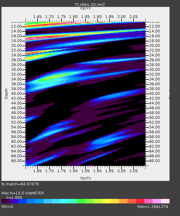
HNVL Huntsville, TX - Earthquake Result Viewer
| Earthquake location: |
Alaska Peninsula |
| Earthquake latitude/longitude: |
55.3/-157.8 |
| Earthquake time(UTC): |
2021/07/29 (210) 06:15:45 GMT |
| Earthquake Depth: |
5.2 km |
| Earthquake Magnitude: |
7.3 ml |
| Earthquake Catalog/Contributor: |
NEIC PDE/ak |
|
| Network: |
TX Texas Seismological Network |
| Station: |
HNVL Huntsville, TX |
| Lat/Lon: |
30.76 N/95.47 W |
| Elevation: |
87 m |
|
| Distance: |
49.8 deg |
| Az: |
92.752 deg |
| Baz: |
318.439 deg |
| Ray Param: |
0.06851255 |
| Estimated Moho Depth: |
10.0 km |
| Estimated Crust Vp/Vs: |
1.86 |
| Assumed Crust Vp: |
5.738 km/s |
| Estimated Crust Vs: |
3.094 km/s |
| Estimated Crust Poisson's Ratio: |
0.30 |
|
| Radial Match: |
94.97879 % |
| Radial Bump: |
400 |
| Transverse Match: |
91.615166 % |
| Transverse Bump: |
400 |
| SOD ConfigId: |
25131211 |
| Insert Time: |
2021-08-12 06:38:34.649 +0000 |
| GWidth: |
2.5 |
| Max Bumps: |
400 |
| Tol: |
0.001 |
|

Signal To Noise
| Channel | StoN | STA | LTA |
| TX:HNVL:00:HHZ:20210729T06:24:07.935Z | 2.4080842 | 4.4272275E-7 | 1.8384854E-7 |
| TX:HNVL:00:HH1:20210729T06:24:07.935Z | 0.77669567 | 1.3331713E-7 | 1.7164655E-7 |
| TX:HNVL:00:HH2:20210729T06:24:07.935Z | 1.1837679 | 1.572707E-7 | 1.3285603E-7 |
| Arrivals |
| Ps | 1.6 SECOND |
| PpPs | 4.8 SECOND |
| PsPs/PpSs | 6.3 SECOND |


