You are here: Home > Network List > TX - Texas Seismological Network Stations List
> Station HNVL Huntsville, TX > Earthquake Result Viewer
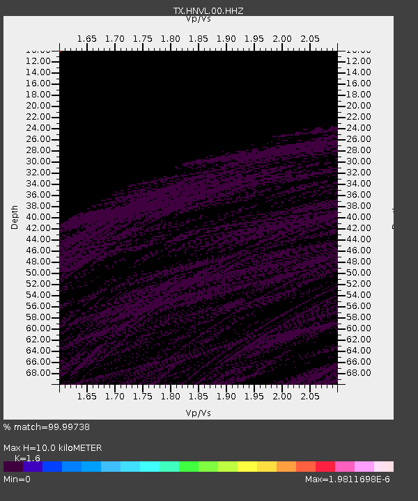
HNVL Huntsville, TX - Earthquake Result Viewer
| Earthquake location: |
Sea Of Okhotsk |
| Earthquake latitude/longitude: |
50.0/149.8 |
| Earthquake time(UTC): |
2021/10/09 (282) 07:19:27 GMT |
| Earthquake Depth: |
448 km |
| Earthquake Magnitude: |
5.6 Mww |
| Earthquake Catalog/Contributor: |
NEIC PDE/us |
|
| Network: |
TX Texas Seismological Network |
| Station: |
HNVL Huntsville, TX |
| Lat/Lon: |
30.76 N/95.47 W |
| Elevation: |
87 m |
|
| Distance: |
81.0 deg |
| Az: |
52.359 deg |
| Baz: |
323.619 deg |
| Ray Param: |
0.046644203 |
| Estimated Moho Depth: |
10.0 km |
| Estimated Crust Vp/Vs: |
1.60 |
| Assumed Crust Vp: |
5.738 km/s |
| Estimated Crust Vs: |
3.587 km/s |
| Estimated Crust Poisson's Ratio: |
0.18 |
|
| Radial Match: |
99.99738 % |
| Radial Bump: |
4 |
| Transverse Match: |
99.99741 % |
| Transverse Bump: |
4 |
| SOD ConfigId: |
26497111 |
| Insert Time: |
2021-10-23 07:42:53.287 +0000 |
| GWidth: |
2.5 |
| Max Bumps: |
400 |
| Tol: |
0.001 |
|

Signal To Noise
| Channel | StoN | STA | LTA |
| TX:HNVL:00:HHZ:20211009T07:30:23.275029Z | 4.1838202 | 0.0134649435 | 0.0032183372 |
| TX:HNVL:00:HH1:20211009T07:30:23.275029Z | 2.2514296 | 8.6415116E-7 | 3.8382333E-7 |
| TX:HNVL:00:HH2:20211009T07:30:23.275029Z | 4.183291 | 0.012214739 | 0.0029198874 |
| Arrivals |
| Ps | 1.1 SECOND |
| PpPs | 4.4 SECOND |
| PsPs/PpSs | 5.5 SECOND |


