You are here: Home > Network List > TX - Texas Seismological Network Stations List
> Station HNVL Huntsville, TX > Earthquake Result Viewer
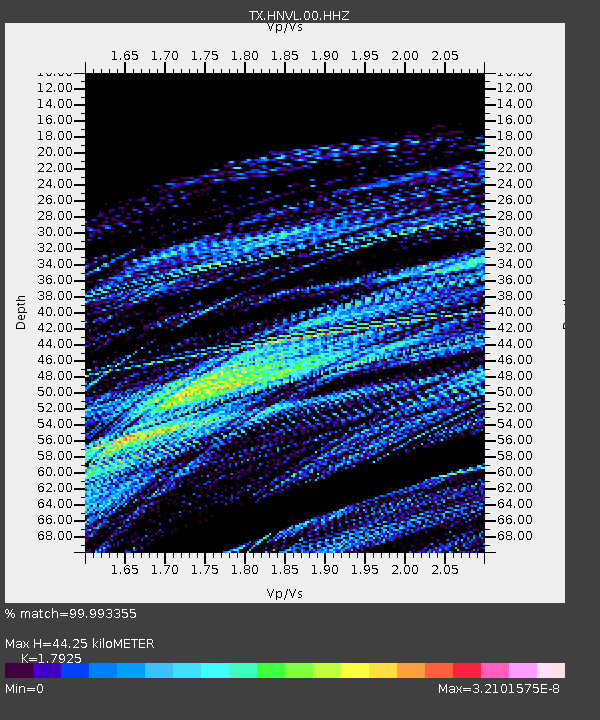
HNVL Huntsville, TX - Earthquake Result Viewer
| Earthquake location: |
Hawaii |
| Earthquake latitude/longitude: |
18.8/-155.5 |
| Earthquake time(UTC): |
2021/10/10 (283) 21:48:36 GMT |
| Earthquake Depth: |
35 km |
| Earthquake Magnitude: |
6.2 Ml |
| Earthquake Catalog/Contributor: |
NEIC PDE/hv |
|
| Network: |
TX Texas Seismological Network |
| Station: |
HNVL Huntsville, TX |
| Lat/Lon: |
30.76 N/95.47 W |
| Elevation: |
87 m |
|
| Distance: |
55.2 deg |
| Az: |
65.23 deg |
| Baz: |
272.476 deg |
| Ray Param: |
0.06485677 |
| Estimated Moho Depth: |
44.25 km |
| Estimated Crust Vp/Vs: |
1.79 |
| Assumed Crust Vp: |
5.738 km/s |
| Estimated Crust Vs: |
3.201 km/s |
| Estimated Crust Poisson's Ratio: |
0.27 |
|
| Radial Match: |
99.993355 % |
| Radial Bump: |
3 |
| Transverse Match: |
99.99309 % |
| Transverse Bump: |
3 |
| SOD ConfigId: |
26497111 |
| Insert Time: |
2021-10-24 22:17:55.512 +0000 |
| GWidth: |
2.5 |
| Max Bumps: |
400 |
| Tol: |
0.001 |
|

Signal To Noise
| Channel | StoN | STA | LTA |
| TX:HNVL:00:HHZ:20211010T21:57:35.515017Z | 0.23735505 | 0.0017044402 | 0.0071809725 |
| TX:HNVL:00:HH1:20211010T21:57:35.515017Z | 1.0787822 | 8.137421E-7 | 7.543154E-7 |
| TX:HNVL:00:HH2:20211010T21:57:35.515017Z | 0.23970495 | 0.0015546322 | 0.0064856075 |
| Arrivals |
| Ps | 6.4 SECOND |
| PpPs | 21 SECOND |
| PsPs/PpSs | 27 SECOND |


