You are here: Home > Network List > TX - Texas Seismological Network Stations List
> Station HNVL Huntsville, TX > Earthquake Result Viewer
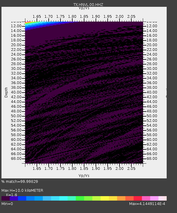
HNVL Huntsville, TX - Earthquake Result Viewer
| Earthquake location: |
Kuril Islands |
| Earthquake latitude/longitude: |
48.3/153.7 |
| Earthquake time(UTC): |
2021/10/11 (284) 23:10:00 GMT |
| Earthquake Depth: |
70 km |
| Earthquake Magnitude: |
5.8 Mww |
| Earthquake Catalog/Contributor: |
NEIC PDE/us |
|
| Network: |
TX Texas Seismological Network |
| Station: |
HNVL Huntsville, TX |
| Lat/Lon: |
30.76 N/95.47 W |
| Elevation: |
87 m |
|
| Distance: |
79.9 deg |
| Az: |
54.827 deg |
| Baz: |
320.651 deg |
| Ray Param: |
0.048486937 |
| Estimated Moho Depth: |
10.0 km |
| Estimated Crust Vp/Vs: |
1.60 |
| Assumed Crust Vp: |
5.738 km/s |
| Estimated Crust Vs: |
3.587 km/s |
| Estimated Crust Poisson's Ratio: |
0.18 |
|
| Radial Match: |
99.99829 % |
| Radial Bump: |
2 |
| Transverse Match: |
99.998314 % |
| Transverse Bump: |
2 |
| SOD ConfigId: |
26497111 |
| Insert Time: |
2021-10-25 23:32:00.034 +0000 |
| GWidth: |
2.5 |
| Max Bumps: |
400 |
| Tol: |
0.001 |
|

Signal To Noise
| Channel | StoN | STA | LTA |
| TX:HNVL:00:HHZ:20211011T23:21:30.860008Z | 10.508306 | 0.010611677 | 0.0010098371 |
| TX:HNVL:00:HH1:20211011T23:21:30.860008Z | 0.9139372 | 4.82952E-7 | 5.284302E-7 |
| TX:HNVL:00:HH2:20211011T23:21:30.860008Z | 10.488938 | 0.009510197 | 9.0668816E-4 |
| Arrivals |
| Ps | 1.1 SECOND |
| PpPs | 4.4 SECOND |
| PsPs/PpSs | 5.5 SECOND |


