You are here: Home > Network List > TA - USArray Transportable Network (new EarthScope stations) Stations List
> Station D22A Cohagen, MT, USA > Earthquake Result Viewer
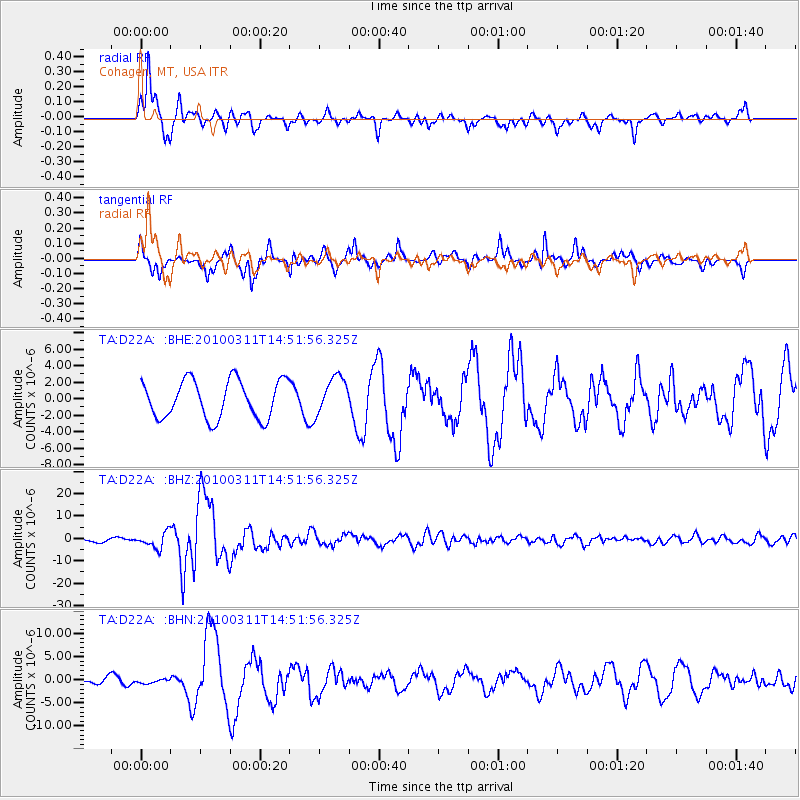
D22A Cohagen, MT, USA - Earthquake Result Viewer
*The percent match for this event was below the threshold and hence no stack was calculated.
| Earthquake location: |
Near Coast Of Central Chile |
| Earthquake latitude/longitude: |
-34.3/-71.9 |
| Earthquake time(UTC): |
2010/03/11 (070) 14:39:43 GMT |
| Earthquake Depth: |
11 km |
| Earthquake Magnitude: |
6.7 MB, 7.0 MS, 6.9 MW, 6.9 MW |
| Earthquake Catalog/Contributor: |
WHDF/NEIC |
|
| Network: |
TA USArray Transportable Network (new EarthScope stations) |
| Station: |
D22A Cohagen, MT, USA |
| Lat/Lon: |
47.15 N/106.18 W |
| Elevation: |
791 m |
|
| Distance: |
86.7 deg |
| Az: |
337.347 deg |
| Baz: |
152.147 deg |
| Ray Param: |
$rayparam |
*The percent match for this event was below the threshold and hence was not used in the summary stack. |
|
| Radial Match: |
93.27555 % |
| Radial Bump: |
396 |
| Transverse Match: |
81.13265 % |
| Transverse Bump: |
372 |
| SOD ConfigId: |
299721 |
| Insert Time: |
2010-04-26 22:07:40.499 +0000 |
| GWidth: |
2.5 |
| Max Bumps: |
400 |
| Tol: |
0.001 |
|
Signal To Noise
| Channel | StoN | STA | LTA |
| TA:D22A: :BHZ:20100311T14:51:56.325Z | 4.231729 | 3.4386135E-6 | 8.1257883E-7 |
| TA:D22A: :BHN:20100311T14:51:56.325Z | 0.20802452 | 4.1633925E-7 | 2.0013952E-6 |
| TA:D22A: :BHE:20100311T14:51:56.325Z | 0.98493516 | 2.2745755E-6 | 2.3093658E-6 |
| Arrivals |
| Ps | |
| PpPs | |
| PsPs/PpSs | |


