You are here: Home > Network List > TA - USArray Transportable Network (new EarthScope stations) Stations List
> Station U31A Nine Bar Ranch, Gage, OK, USA > Earthquake Result Viewer
U31A Nine Bar Ranch, Gage, OK, USA - Earthquake Result Viewer
| Earthquake location: |
Northern Mid-Atlantic Ridge |
| Earthquake latitude/longitude: |
23.9/-46.1 |
| Earthquake time(UTC): |
2009/06/06 (157) 20:33:28 GMT |
| Earthquake Depth: |
14 km |
| Earthquake Magnitude: |
6.0 MB, 5.7 MS, 6.0 MW, 6.0 MW |
| Earthquake Catalog/Contributor: |
WHDF/NEIC |
|
| Network: |
TA USArray Transportable Network (new EarthScope stations) |
| Station: |
U31A Nine Bar Ranch, Gage, OK, USA |
| Lat/Lon: |
36.37 N/99.85 W |
| Elevation: |
725 m |
|
| Distance: |
47.6 deg |
| Az: |
298.167 deg |
| Baz: |
89.608 deg |
| Ray Param: |
0.06988401 |
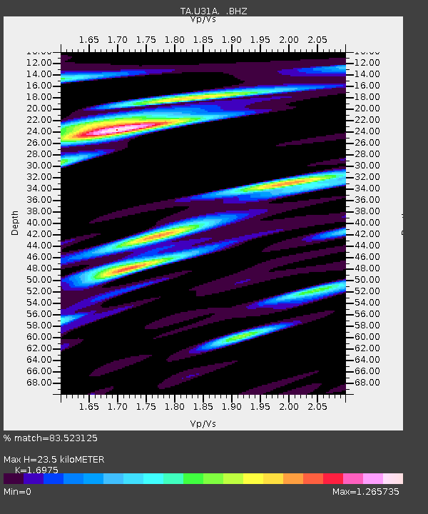
| Estimated Moho Depth: |
23.5 km |
| Estimated Crust Vp/Vs: |
1.70 |
| Assumed Crust Vp: |
6.426 km/s |
| Estimated Crust Vs: |
3.786 km/s |
| Estimated Crust Poisson's Ratio: |
0.23 |
|
| Radial Match: |
83.523125 % |
| Radial Bump: |
400 |
| Transverse Match: |
65.67006 % |
| Transverse Bump: |
400 |
| SOD ConfigId: |
2648 |
| Insert Time: |
2010-03-06 01:02:01.195 +0000 |
| GWidth: |
2.5 |
| Max Bumps: |
400 |
| Tol: |
0.001 |
|
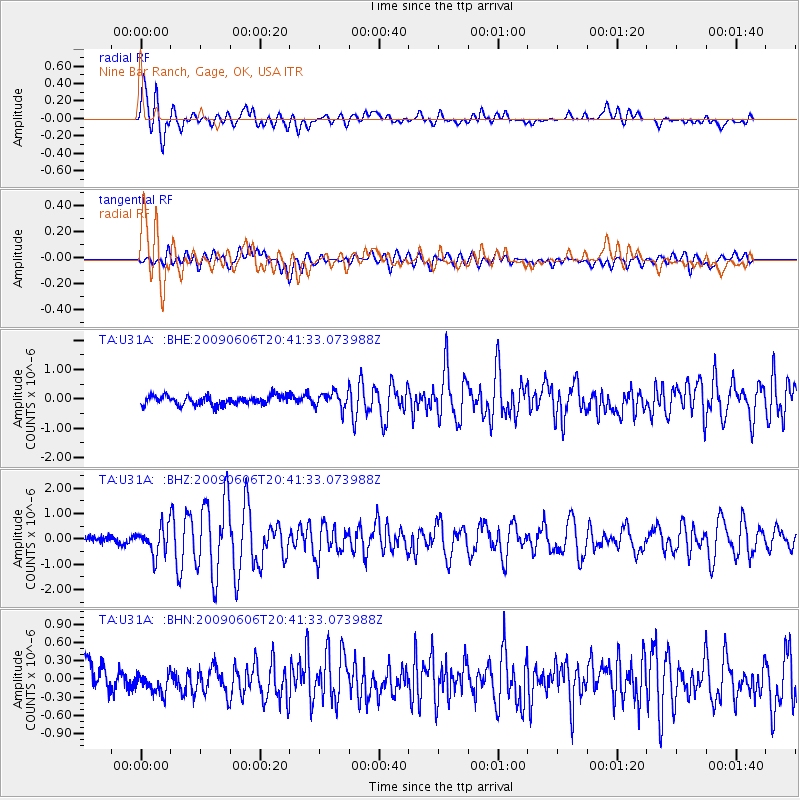
Signal To Noise
| Channel | StoN | STA | LTA |
| TA:U31A: :BHZ:20090606T20:41:33.073988Z | 3.18473 | 5.468025E-7 | 1.7169508E-7 |
| TA:U31A: :BHN:20090606T20:41:33.073988Z | 1.1012635 | 1.794204E-7 | 1.629223E-7 |
| TA:U31A: :BHE:20090606T20:41:33.073988Z | 1.7397045 | 2.668094E-7 | 1.5336478E-7 |
| Arrivals |
| Ps | 2.7 SECOND |
| PpPs | 9.3 SECOND |
| PsPs/PpSs | 12 SECOND |


