You are here: Home > Network List > TA - USArray Transportable Network (new EarthScope stations) Stations List
> Station U31A Nine Bar Ranch, Gage, OK, USA > Earthquake Result Viewer
U31A Nine Bar Ranch, Gage, OK, USA - Earthquake Result Viewer
| Earthquake location: |
Tonga Islands |
| Earthquake latitude/longitude: |
-21.9/-174.8 |
| Earthquake time(UTC): |
2010/02/13 (044) 02:34:28 GMT |
| Earthquake Depth: |
11 km |
| Earthquake Magnitude: |
6.0 MB, 6.2 MS, 6.1 MW, 6.0 MW |
| Earthquake Catalog/Contributor: |
WHDF/NEIC |
|
| Network: |
TA USArray Transportable Network (new EarthScope stations) |
| Station: |
U31A Nine Bar Ranch, Gage, OK, USA |
| Lat/Lon: |
36.37 N/99.85 W |
| Elevation: |
725 m |
|
| Distance: |
91.4 deg |
| Az: |
51.217 deg |
| Baz: |
243.759 deg |
| Ray Param: |
0.041606747 |
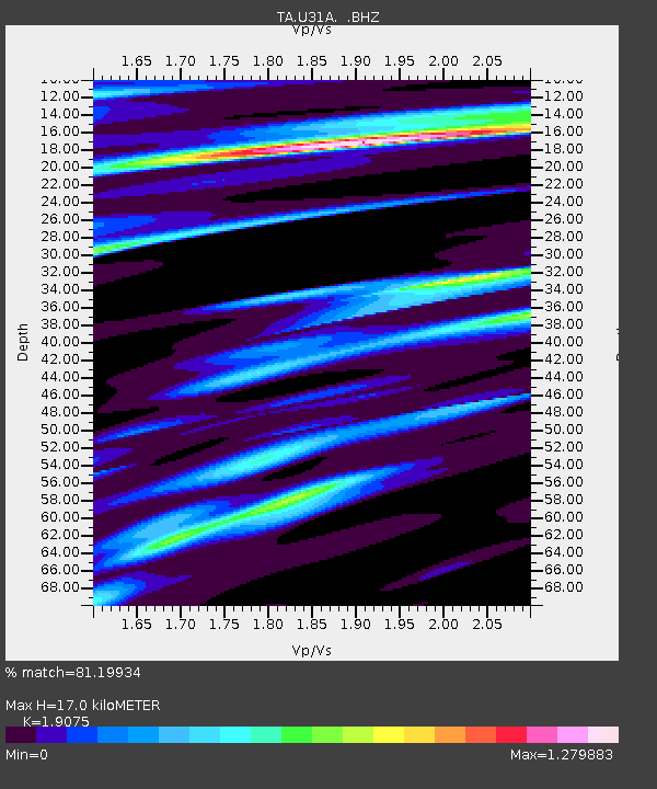
| Estimated Moho Depth: |
17.0 km |
| Estimated Crust Vp/Vs: |
1.91 |
| Assumed Crust Vp: |
6.426 km/s |
| Estimated Crust Vs: |
3.369 km/s |
| Estimated Crust Poisson's Ratio: |
0.31 |
|
| Radial Match: |
81.19934 % |
| Radial Bump: |
379 |
| Transverse Match: |
45.75245 % |
| Transverse Bump: |
378 |
| SOD ConfigId: |
306082 |
| Insert Time: |
2010-05-06 07:25:53.074 +0000 |
| GWidth: |
2.5 |
| Max Bumps: |
400 |
| Tol: |
0.001 |
|

Signal To Noise
| Channel | StoN | STA | LTA |
| TA:U31A: :BHZ:20100213T02:47:03.050002Z | 0.97138274 | 1.0061093E-6 | 1.0357496E-6 |
| TA:U31A: :BHN:20100213T02:47:03.050002Z | 0.9987908 | 1.3317364E-6 | 1.3333486E-6 |
| TA:U31A: :BHE:20100213T02:47:03.050002Z | 2.6982334 | 1.6508023E-6 | 6.118086E-7 |
| Arrivals |
| Ps | 2.4 SECOND |
| PpPs | 7.5 SECOND |
| PsPs/PpSs | 10.0 SECOND |


