You are here: Home > Network List > TA - USArray Transportable Network (new EarthScope stations) Stations List
> Station U31A Nine Bar Ranch, Gage, OK, USA > Earthquake Result Viewer
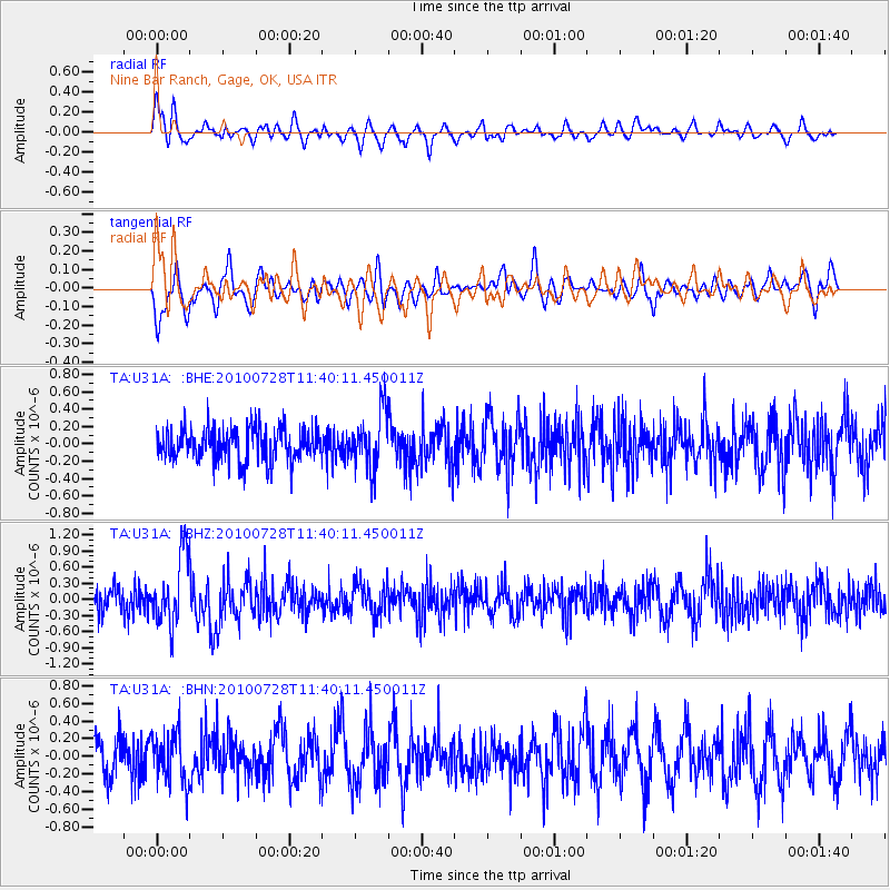
U31A Nine Bar Ranch, Gage, OK, USA - Earthquake Result Viewer
*The percent match for this event was below the threshold and hence no stack was calculated.
| Earthquake location: |
Fox Islands, Aleutian Islands |
| Earthquake latitude/longitude: |
52.7/-169.4 |
| Earthquake time(UTC): |
2010/07/28 (209) 11:31:46 GMT |
| Earthquake Depth: |
10 km |
| Earthquake Magnitude: |
5.6 MW, 5.2 MS, 5.2 MB, 5.1 ML |
| Earthquake Catalog/Contributor: |
WHDF/NEIC |
|
| Network: |
TA USArray Transportable Network (new EarthScope stations) |
| Station: |
U31A Nine Bar Ranch, Gage, OK, USA |
| Lat/Lon: |
36.37 N/99.85 W |
| Elevation: |
725 m |
|
| Distance: |
50.2 deg |
| Az: |
79.807 deg |
| Baz: |
312.041 deg |
| Ray Param: |
$rayparam |
*The percent match for this event was below the threshold and hence was not used in the summary stack. |
|
| Radial Match: |
59.763153 % |
| Radial Bump: |
400 |
| Transverse Match: |
63.434704 % |
| Transverse Bump: |
400 |
| SOD ConfigId: |
319893 |
| Insert Time: |
2011-01-05 13:37:31.688 +0000 |
| GWidth: |
2.5 |
| Max Bumps: |
400 |
| Tol: |
0.001 |
|
Signal To Noise
| Channel | StoN | STA | LTA |
| TA:U31A: :BHZ:20100728T11:40:11.450011Z | 2.894319 | 6.3877957E-7 | 2.2070117E-7 |
| TA:U31A: :BHN:20100728T11:40:11.450011Z | 1.0489215 | 2.8777944E-7 | 2.743575E-7 |
| TA:U31A: :BHE:20100728T11:40:11.450011Z | 1.6943806 | 3.207144E-7 | 1.892812E-7 |
| Arrivals |
| Ps | |
| PpPs | |
| PsPs/PpSs | |


