You are here: Home > Network List > TA - USArray Transportable Network (new EarthScope stations) Stations List
> Station U31A Nine Bar Ranch, Gage, OK, USA > Earthquake Result Viewer
U31A Nine Bar Ranch, Gage, OK, USA - Earthquake Result Viewer
| Earthquake location: |
Near Coast Of Central Chile |
| Earthquake latitude/longitude: |
-37.0/-73.4 |
| Earthquake time(UTC): |
2010/09/09 (252) 07:28:01 GMT |
| Earthquake Depth: |
16 km |
| Earthquake Magnitude: |
5.8 MB, 6.0 MS, 6.2 MW, 6.2 MW |
| Earthquake Catalog/Contributor: |
WHDF/NEIC |
|
| Network: |
TA USArray Transportable Network (new EarthScope stations) |
| Station: |
U31A Nine Bar Ranch, Gage, OK, USA |
| Lat/Lon: |
36.37 N/99.85 W |
| Elevation: |
725 m |
|
| Distance: |
77.0 deg |
| Az: |
338.362 deg |
| Baz: |
158.555 deg |
| Ray Param: |
0.05057789 |
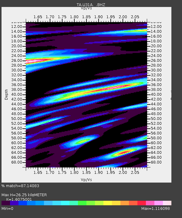
| Estimated Moho Depth: |
26.25 km |
| Estimated Crust Vp/Vs: |
1.61 |
| Assumed Crust Vp: |
6.426 km/s |
| Estimated Crust Vs: |
3.998 km/s |
| Estimated Crust Poisson's Ratio: |
0.18 |
|
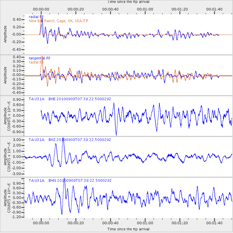
| Radial Match: |
87.14083 % |
| Radial Bump: |
400 |
| Transverse Match: |
75.213036 % |
| Transverse Bump: |
400 |
| SOD ConfigId: |
319893 |
| Insert Time: |
2011-01-13 09:42:01.182 +0000 |
| GWidth: |
2.5 |
| Max Bumps: |
400 |
| Tol: |
0.001 |
|
Signal To Noise
| Channel | StoN | STA | LTA |
| TA:U31A: :BHZ:20100909T07:39:22.500029Z | 1.8496106 | 2.40548E-7 | 1.3005332E-7 |
| TA:U31A: :BHN:20100909T07:39:22.500029Z | 0.8070979 | 1.1727095E-7 | 1.4529954E-7 |
| TA:U31A: :BHE:20100909T07:39:22.500029Z | 1.1311097 | 1.949324E-7 | 1.723373E-7 |
| Arrivals |
| Ps | 2.6 SECOND |
| PpPs | 10 SECOND |
| PsPs/PpSs | 13 SECOND |


