You are here: Home > Network List > SC - New Mexico Tech Seismic Network Stations List
> Station HOB5 Hobbs 5 > Earthquake Result Viewer
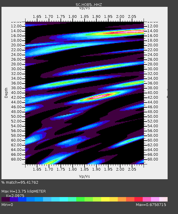
HOB5 Hobbs 5 - Earthquake Result Viewer
| Earthquake location: |
Alaska Peninsula |
| Earthquake latitude/longitude: |
54.5/-160.8 |
| Earthquake time(UTC): |
2023/07/16 (197) 06:48:21 GMT |
| Earthquake Depth: |
21 km |
| Earthquake Magnitude: |
7.3 Mi |
| Earthquake Catalog/Contributor: |
NEIC PDE/at |
|
| Network: |
SC New Mexico Tech Seismic Network |
| Station: |
HOB5 Hobbs 5 |
| Lat/Lon: |
32.86 N/103.57 W |
| Elevation: |
1239 m |
|
| Distance: |
45.2 deg |
| Az: |
94.441 deg |
| Baz: |
316.28 deg |
| Ray Param: |
0.07140164 |
| Estimated Moho Depth: |
13.75 km |
| Estimated Crust Vp/Vs: |
2.10 |
| Assumed Crust Vp: |
6.129 km/s |
| Estimated Crust Vs: |
2.922 km/s |
| Estimated Crust Poisson's Ratio: |
0.35 |
|
| Radial Match: |
95.41762 % |
| Radial Bump: |
400 |
| Transverse Match: |
95.46048 % |
| Transverse Bump: |
400 |
| SOD ConfigId: |
34243671 |
| Insert Time: |
2024-05-05 03:13:47.356 +0000 |
| GWidth: |
2.5 |
| Max Bumps: |
400 |
| Tol: |
0.001 |
|

Signal To Noise
| Channel | StoN | STA | LTA |
| SC:HOB5: :HHZ:20230716T06:56:05.158997Z | 7.8512154 | 5.042874E-7 | 6.423049E-8 |
| SC:HOB5: :HH1:20230716T06:56:05.158997Z | 1.0019082 | 5.2690585E-9 | 5.259024E-9 |
| SC:HOB5: :HH2:20230716T06:56:05.158997Z | 2.3163612 | 1.8342973E-7 | 7.9188744E-8 |
| Arrivals |
| Ps | 2.6 SECOND |
| PpPs | 6.6 SECOND |
| PsPs/PpSs | 9.2 SECOND |


