You are here: Home > Network List > NN - Western Great Basin/Eastern Sierra Nevada Stations List
> Station MPK Martis Peak, California w84gm > Earthquake Result Viewer
MPK Martis Peak, California w84gm - Earthquake Result Viewer
| Earthquake location: |
Vanuatu Islands |
| Earthquake latitude/longitude: |
-14.4/166.8 |
| Earthquake time(UTC): |
2016/04/03 (094) 08:23:53 GMT |
| Earthquake Depth: |
35 km |
| Earthquake Magnitude: |
6.9 MWW, 7.2 MI |
| Earthquake Catalog/Contributor: |
NEIC PDE/NEIC COMCAT |
|
| Network: |
NN Western Great Basin/Eastern Sierra Nevada |
| Station: |
MPK Martis Peak, California w84gm |
| Lat/Lon: |
39.29 N/120.04 W |
| Elevation: |
2599 m |
|
| Distance: |
86.4 deg |
| Az: |
48.084 deg |
| Baz: |
248.338 deg |
| Ray Param: |
0.044030804 |
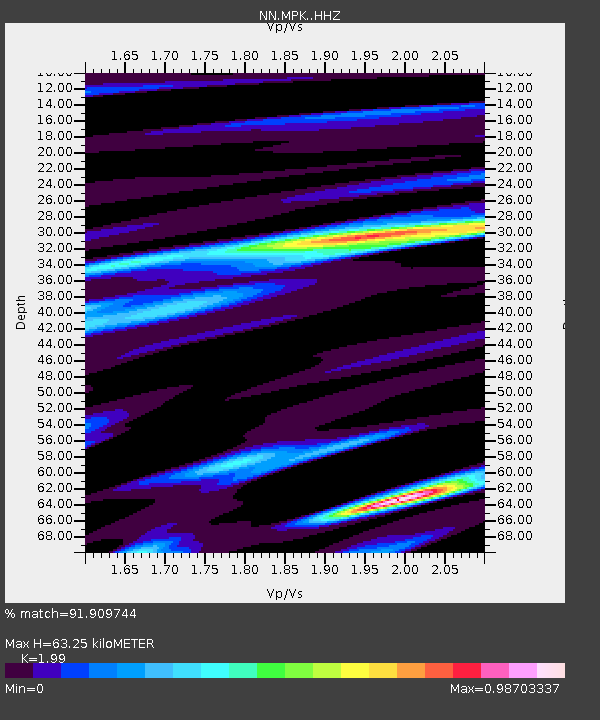
| Estimated Moho Depth: |
63.25 km |
| Estimated Crust Vp/Vs: |
1.99 |
| Assumed Crust Vp: |
6.597 km/s |
| Estimated Crust Vs: |
3.315 km/s |
| Estimated Crust Poisson's Ratio: |
0.33 |
|
| Radial Match: |
91.909744 % |
| Radial Bump: |
400 |
| Transverse Match: |
77.85875 % |
| Transverse Bump: |
400 |
| SOD ConfigId: |
7422571 |
| Insert Time: |
2019-04-22 03:33:27.750 +0000 |
| GWidth: |
2.5 |
| Max Bumps: |
400 |
| Tol: |
0.001 |
|

Signal To Noise
| Channel | StoN | STA | LTA |
| NN:MPK: :HHZ:20160403T08:36:00.70802Z | 18.935068 | 3.1439024E-6 | 1.6603597E-7 |
| NN:MPK: :HHN:20160403T08:36:00.70802Z | 3.4438696 | 6.2523753E-7 | 1.8155086E-7 |
| NN:MPK: :HHE:20160403T08:36:00.70802Z | 6.8512883 | 1.0612866E-6 | 1.549032E-7 |
| Arrivals |
| Ps | 9.7 SECOND |
| PpPs | 28 SECOND |
| PsPs/PpSs | 38 SECOND |


