You are here: Home > Network List > NN - Western Great Basin/Eastern Sierra Nevada Stations List
> Station MPK Martis Peak, California w84gm > Earthquake Result Viewer
MPK Martis Peak, California w84gm - Earthquake Result Viewer
| Earthquake location: |
Near Coast Of Ecuador |
| Earthquake latitude/longitude: |
-0.3/-80.5 |
| Earthquake time(UTC): |
2016/04/17 (108) 00:29:31 GMT |
| Earthquake Depth: |
16 km |
| Earthquake Magnitude: |
5.5 MB |
| Earthquake Catalog/Contributor: |
NEIC PDE/NEIC COMCAT |
|
| Network: |
NN Western Great Basin/Eastern Sierra Nevada |
| Station: |
MPK Martis Peak, California w84gm |
| Lat/Lon: |
39.29 N/120.04 W |
| Elevation: |
2599 m |
|
| Distance: |
53.5 deg |
| Az: |
322.032 deg |
| Baz: |
127.552 deg |
| Ray Param: |
0.06606539 |
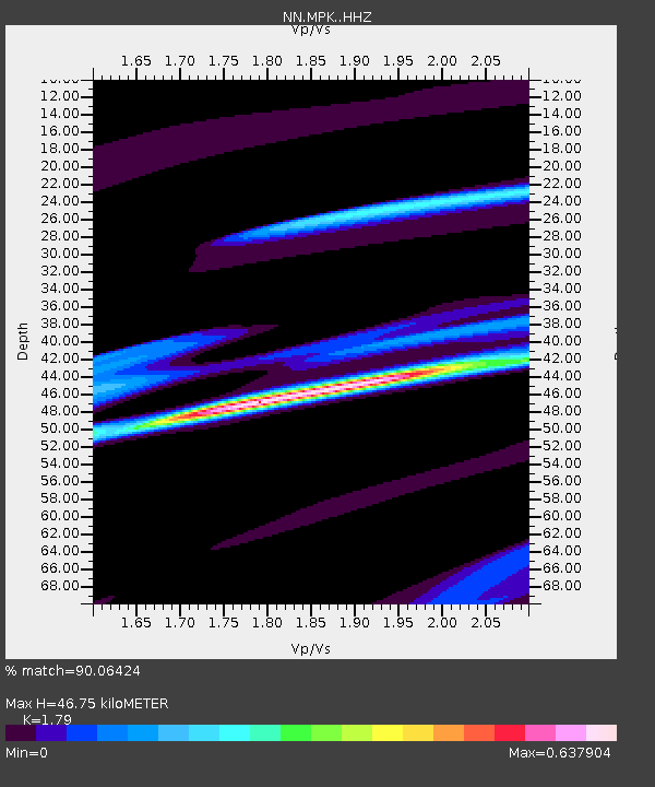
| Estimated Moho Depth: |
46.75 km |
| Estimated Crust Vp/Vs: |
1.79 |
| Assumed Crust Vp: |
6.597 km/s |
| Estimated Crust Vs: |
3.686 km/s |
| Estimated Crust Poisson's Ratio: |
0.27 |
|
| Radial Match: |
90.06424 % |
| Radial Bump: |
321 |
| Transverse Match: |
39.265316 % |
| Transverse Bump: |
277 |
| SOD ConfigId: |
7422571 |
| Insert Time: |
2019-04-22 08:17:11.280 +0000 |
| GWidth: |
2.5 |
| Max Bumps: |
400 |
| Tol: |
0.001 |
|

Signal To Noise
| Channel | StoN | STA | LTA |
| NN:MPK: :HHZ:20160417T00:38:19.757991Z | 1.6619871 | 6.408112E-5 | 3.855693E-5 |
| NN:MPK: :HHN:20160417T00:38:19.757991Z | 1.608161 | 5.3140076E-5 | 3.3044005E-5 |
| NN:MPK: :HHE:20160417T00:38:19.757991Z | 0.8070838 | 2.3076778E-5 | 2.8592793E-5 |
| Arrivals |
| Ps | 5.9 SECOND |
| PpPs | 19 SECOND |
| PsPs/PpSs | 25 SECOND |


